Steve Davison heads to Barton on Sea for a coastal walk with views across to the Isle of Wight
This month we head to Barton on Sea, tucked in the south-western corner overlooking Christchurch Bay, midway between Lymington and Christchurch. Although the village looks fairly recent, the area’s history goes back several millennia as various Bronze Age artefacts have been found locally. Before setting out, take a look at the small obelisk at the junction of Marine Drive and Barton Court Avenue (north end of the small triangular green). This was placed here in 1917 to commemorate the convalescent home at Barton Court (now mostly lost to sea erosion) for Indian troops who fought during the Great War.
After leaving Marine Drive East we head across Long Meadow to reach Barton Common, an area of woodland and open heath that was once part of the New Forest. To help preserve the interesting range of wildlife, several New Forest ponies have recently been re-introduced to the common.
The walk then heads through fields and woods to reach the Royal Oak at Downton; the hamlet was first mentioned in the 12th century. Some 700m north along Hordle Lane is the Apple Court Gardens (01590 642130). This compact garden has been created in the abandoned walled kitchen garden of Yeatton House, and has been designed as a series of interlocking areas, including a Japanese garden, sub-tropical borders and a white garden.
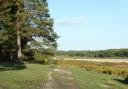
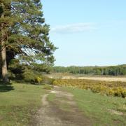
From Downton we head south back to the coast for some lovely views looking out across Christchurch Bay from Milford on Sea (left) to Hengistbury Head (right), and including the Isle of Wight and The Needles, as well as the more distant chalk cliffs of the Purbeck Downs. The final section meanders along the cliff-top path back to Barton on Sea, crossing Beckton Bunny on the way.
The cliffs are formed from layers of clay and sand that were laid down in shallow seas around 40 million years ago and are known as the Barton Beds. These relatively soft rocks are easily eroded and parts of the coastline, which have not been protected, are being eroded at a rate of 0.5 to 1m per year. The Barton Beds are famed for their fossils, especially shells such as gastropods, as well as the odd shark tooth - one of the best areas is along the water’s edge just to the west of Barton as far as Chewton Bunny.
If you have some spare time whilst in the area, call in at the Sammy Miller Motorcycle Museum at New Milton (01425 620777) to see a fascinating collection of over 350 rare and classic motorcycles (2 miles north of the walk start point).
Information
• Distance: 5 miles (7.9km) or 3.25 miles (5.2km)
• Time: 2.5 hours without stops (1.5 hours)
• Terrain: Some gentle ups and downs, tracks and paths which can be muddy, no stiles, some gates, sections of road
• Start/Finish: Barton on Sea (SZ239929) at the junction of Marine Drive East and Barton Court Avenue; on-street and pay and display parking available locally
• Map: OS Explorer OL22
• Refreshments: Beachcomber Cafe (01425 611599) at Barton on Sea; The Royal Oak (01590 718104) at Downton
The walk
1 (SZ239929) – From Beachcomber Cafe head eastwards along Marine Drive East and take the second left along Second Marine Avenue. Cross over Grove Road and bear diagonally right across the open grassy area, Long Meadow, crossing the stream (Becton Bunny) via one of the two footbridges. At the far right-hand side cross over Becton Lane and turn left for 50m. Where the pavement ends, fork right along a path through the trees, soon forking left to a road and turn right to reach a parking area (alternative start). From the car park go through the gate and follow the path along the left-hand edge of Barton Common, leave through a gate in the northern edge.
2 (SZ252934) – Turn right along the road for 100m then turn along Angel Lane for 400m. Immediately after Angels Cottage, turn right through a gate and continue across the large field to the southern corner. Enter the wood and turn left along the track (shortcut: turn right, cross the road and follow the waymarked path across the golf course to rejoin the main walk near Beckton Bunny). At the track junction keep straight on (yellow marker) and ignore private tracks right and left. Drop down to cross a footbridge and keep ahead. Leave the trees and continue straight on across the field, go through a kissing gate and turn right along the road to reach the Royal Oak (700m to the north along Hordle Lane is the Apple Court Garden).
3 (SZ269935) – Turn right along Downton Lane for 300m, then right through a kissing gate. Follow the track and fence line towards the trees. Turn left through a kissing gate and follow the edge of the wood (trees on the right), later bearing right down to a footbridge. Cross over Danes Stream and keep ahead through the field following the left-hand fence. Go through a kissing gate, then up the steps to the road (B3058). Turn right for 50m and then left to enter Taddiford Gap car park (alternative start).
4 (SZ263926) – From the far-left corner follow the signposted path to the coastal path and turn right, keeping the sea on the left and the golf course on the right (after 600m the shortcut rejoins from the right). Keep alongside Beckton Bunny chine to a path junction and bear left to continue along the coastal path for three-quarters of a mile back to the start.