

Enjoy plenty of spectacular Derbyshire dales and panoramic Peak District landscape in this wonderful scenic walk
Route
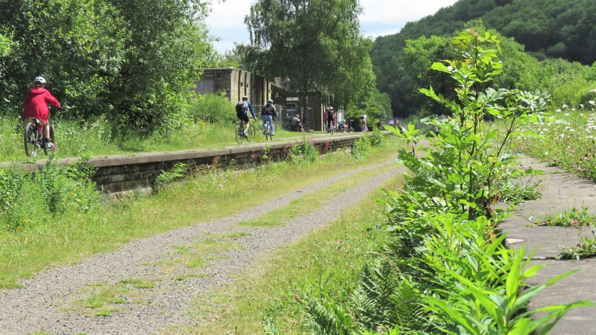
1. Walk in front of the former station building and down to a fingerpost sign on the trail. Turn right and follow the directions for Wye Dale.
Millers Dale Station was built in 1863 to serve the Midland Railway. It was one of the largest stations on the line and had the rare facility of a railside post office. Originally built with two platforms and one viaduct over the nearby river and gorge, the station became so popular with visitors that a second viaduct was constructed in 1905, along with three further platforms that could cater for the hordes of visitors arriving from nearby cities and towns who wanted to escape at weekends to the hills for the price of a cheap away-day return ticket. Millers Dale station closed in 1967 with the last train passing through in 1968. In summer, land around the station is rich with wild flowers providing a riot of colour. After 100 yards, turn left at a further fingerpost for Millers Dale and descend steps to the river level.

2. Go through a gap stile to access the riverside path and proceed upstream. Watch for dippers that appear like monochrome robins skimming above the surface and look for water voles, sadly now a rare sight. The path goes beneath a high arched bridge where water gurgles past at speed before calming down into deeper stretches and pools where trout may well linger.
3. Arriving at a metal footbridge over the river at the entrance to Chee Dale, turn right and go through a gate to follow the footpath uphill to Wormhill. Over time it has been eroded down to slippery limestone bedrock. The sides of the dale hereabouts are managed and conserved by occasionally allowing highland cattle to graze as they will eat away scrub and undergrowth whilst naturally manuring the ground. Look for wild flowers and keep glancing behind you as sweeping views emerge down the valley.

4. On reaching Chee Tor Cottage on the outskirts of Wormhill bear left and follow a short stretch of grassy track to avoid walking along the road where there is no footway. Notice Wormhill Hall nestling in a sheltered hollow on the other side of the road surrounded by trees. It was built in 1697 and is home to the Bagshawe family who have owned the manor of Wormhill since the middle of the 15th century.
5. Just before the sign to indicate that you are entering the village, go through a gated stile and cross an area of grass between the green shed on your left and Hassop farmhouse on your right. Go through a gateway between old buildings to a fingerpost sign and narrow gate in the wall beyond. Follow the sign for ‘Public Footpath Meadow’ heading diagonally right across fields and stiles.

6. After walking downhill in the third field you will come to a wooden stile by a gate. Now head down to a fence and then around to your right to descend a steep path which leads into Flag Dale. Ascend a path on the opposite side to a little set of stone stile posts and a gate at the top of the bank. Please be sure to keep dogs on leads as there are generally sheep grazing in these fields.
7. Head uphill and diagonally right across two fields to a gate and fingerpost sign. Continue ahead along a walled grassy path and then through a narrow gate at the entrance to the farm.

8. Walk directly through the yard of Mosley Farm to the far side where you will come to a sign for the Pennine Bridleway. Turn left and head steeply downhill to Chee Dale admiring the fantastic views as you go. Look to the skies to see buzzards soaring overhead and listen for the sound of the peregrine falcons which sometimes nest hereabouts.
Far below is a little cluster of properties at Blackwell Mill on the site of a medieval corn mill. Centuries ago pack ponies would have passed here by descending a little valley from the vicinity of what is now the lay-by at the side of the A6 opposite. They would have had to ford the river and then head off towards Buxton up Great Rocks Dale which leads up to Peak Dale.
Long exploited for its limestone, the top part of Great Rocks Dale now forms part of Tunstead Quarry, a ‘super quarry’ producing building stone, aggregates, lime and cement with a workforce of some 400 employees.

9. Go through a bridle-gate near the bottom of the path to access a stretch of redundant railway track bed and turn left. This will then unite with the main Monsal Trail.
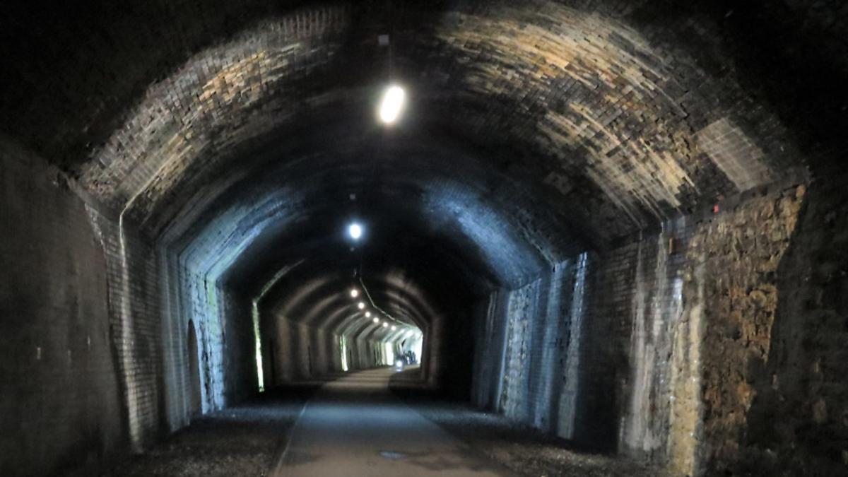
10. Follow the signs for Bakewell and walk along the trail. As you go, marvel at the incredible engineering skills of the Victorian era that enabled this railway to be laid through an almost impenetrable gorge, resulting in high arched bridges and massive embankments being constructed along with a series of long tunnels that had to be driven through hard limestone. At times glance down to see moss-encrusted trees far below or look across to crags and buttress cliffs striped by minerals leeching out of the limestone.
11. You will pass through Rusher Cutting Tunnel first, which is not very long, then come to Chee Tor Tunnel No 2 – a short burst of shadow – before experiencing the main Chee Tor tunnel which is illuminated by a long line of lights that curve around a bend, enticing you to enter.
12. Emerging from the tunnel you will cross a viaduct which is often used for abseiling by organised groups. Beyond this you will pass huge redundant lime kilns supported by buttress pillars. These lime works were operated by the East Buxton Lime Firms – an amalgamation of a dozen small companies – and were in operation from 1880-1944. In their heyday they could produce some 50 tons of quicklime a day for use in the steel and chemical industries as well as for agriculture. This whole site is now a nature reserve and wildlife conservation area. Continue along the trail leading you directly back to Millers Dale Station car park.
FACT FILE
Distance: 5 miles
Parking: Millers Dale Station SK17 8SN (pay & display). Grid Ref: 138733
Toilets: Millers Dale Station
Map: O.S. Explorer OL24 – White Peak
Terrain: 7 gates, 6 stiles. Long descent of steps. Close proximity to deep water. Woodland paths and trip hazards. Fields with livestock grazing. Steep pathway down into Chee Dale. Section of walking along Monsal Trail used also by cyclists and horse riders. Long tunnel with lighting that goes off at dusk.
Walk highlight: Descent into Chee Dale
Refreshments: Light refreshments sometimes available at Millers Dale Station (mobile kiosk & garden tearoom)
Description: Beginning with a riverside amble beside the Wye, this walk gently ascends to White Peak upland to enjoy far- reaching views over a truly magnificent landscape. After passing through a succession of fields and stiles, the route then zig-zags steeply down a section of the Pennine Bridleway to finish with a stretch of easy walking along part of the famous Monsal Trail.


