Head to the New Forest for a winter walk around Brockenhurst and enjoy some festive fare, too, at one of its many pubs, restaurants or cafés says Fiona Barltrop
Surrounded by beautiful woodland, heath and grassland, the attractive village of Brockenhurst, with its free-roaming ponies and donkeys, makes an ideal walking base. At the western end of the main street, Brookley Road, is a picturesque ford, the Watersplash, and there’s a second, lesser-known ford, as well.
There’s much of historic interest too: St Nicholas’ Church, just outside the village, is the oldest in the New Forest with a great yew tree, which is over 1000 years old. Here, you’ll also find the war graves for WWI New Zealand soldiers. In 1914, the War Office designated Brockenhurst a key hospital centre. 3,500 Indian troops and 21,000 New Zealand troops were treated here. As well as the now former New Zealand General Hospital, two hotels – Balmer Lawn and Forest Park - were requisitioned for hospital use. A memorial stained-glass window in the church, a gift from the people of New Zealand, was unveiled in 2016. Meerut Road, which adjoins the grassland known as Butts Lawn (lawn is a New Forest word for a grassy area used for grazing), was named in honour of the 7th Meerut Indian Army Division who were among the first casualties to arrive in the village in 1914. Brockenhurst itself lost a sizable number of local men.

Another grave of note in the churchyard is that of Harry ‘Brusher’ Mills (1840 – 1905), who was quite a character. He lived in a disused charcoal burner and was famed for catching snakes, although the name Brusher came about from his brushing or sweeping of the cricket pitch before a game. The Snakecatcher pub in Brockenhurst is named after him.
his is just one of a wide selection of places to eat and drink that you’ll find in the village. These include award-winning restaurants, cafés and pubs, where you can enjoy some festive fare at the end of the walk.

The walk
1 (SU303031) Turn left out of the Balmer Lawn car park to the main road, and right alongside it crossing the Lymington River. Take the next road on the right, Meerut Road, cross a cattle grid and continue beside the green on the left, ignoring a right turn. Bear left at the road junction and continue along Meerut Road - you can walk on the grass on the right, if preferred - passing a gravel track with a barrier on the right.
2 (SU295026) Just before the next road junction, turn right at a second gravel track, soon crossing a footbridge. Continue along this track (which peters out near the end) to the far corner of Black Knowl. Note the numbered wooden post – these are used for cycle trails in the Forest. The walk turns left here, but Bolderford Bridge, nearby to the right, is worth a brief detour.
3 (SU290040) Turn left along the wide gravel track, keeping ahead along the road at Ober Corner for 250 yards (230m).
4 (SU283033) Turn right along the track signed for Aldridge Hill campsite, crossing a bridge over Ober Water (which joins the Highland Water to become the Lymington River). Turn left along a path beside the stream through the trees, and in about 300 yards (250m) re-cross the Ober Water via a footbridge on the left. Keep ahead along a pine-fringed path to the road. Bear right and follow the road as it bends left, walking along the grass on the right. Keep to the right of the car park to reach the road opposite a gravel track (road junction nearby to the left).
5 (SU284026) Cross the road and follow the track, passing the houses of North Weirs on your left, the open heathland of White Moor on the right.
6 (SU293020) At the road turn left, and follow the roadside paths, passing striking St Saviour’s Church on the left. This is a much later building than St Nicholas’ Church (yet to be visited), having been built between 1895 and 1905. It is a fine example of late Victorian architecture. Continue past the Watersplash/ford on the right for 120 yards (110m) to a small wooden gate on the right with a fingerpost beside it.
7 (SU297023) Turn right through the gate and follow the path beside the stream to another ford. For the most direct route back to the car park, turn left to Meerut Road, and turn right to retrace initial steps.

To visit St Nicholas’ Church, turn right, ignoring roads to left and right, and keep ahead at the Burford Lane turn on the left. At the junction cross the road and continue along Waters Green bearing left. Follow this to the main road/A337, turn right, then fork left along North Road (no through road), the Huntsman opposite. At the end of the road, cross the bridge over the railway and continue to the road. Opposite is the impressive North Lodge gatehouse at the entrance to Brockenhurst Park. Turn right and very soon left along a gravel track which leads to St Nicholas’ Church. Retrace steps to the main road, and turn right back to the car park.

Compass Points
Start/finish: Balmer Lawn car park (SU303031) – free parking. Alternatively, Brookley Road car park in village (charges apply).
Map: OS Explorer OL22
Distance: 5¼ miles/8.4 km (or 6½ miles/10.3km including extension to church)
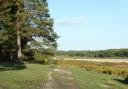
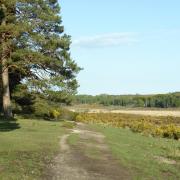
Terrain: Village roads, gravel tracks, grassy and woodland paths. Easy walking.
Time: 2½ - 3 hours
Refreshments: Plenty of choice in Brockenhurst
Public transport: Brockenhurst station is on the South Western Railway mainline from London Waterloo to Weymouth. There are also Blue Star bus services and National Express coaches.