An undulating hike uphill and down dale - with a fabulous display of snowdrops
DESCRIPTION: This walk, tucked away among limestone hills on the county border, initially descends to the Dove down a quiet lane to the picture postcard village of Milldale. After a riverside wander the ascent up Hall Dale offers a reward in early spring – a fabulous storm of snowdrops around Stanshope. The end of the walk follows a roller-coaster ancient path with scenic views.
DISTANCE: 4.5 miles
PARKING: Free car parks beside the Memorial Hall and next to the toilet block in Alstonefield DE6 2FX. Grid Ref: SK 130556
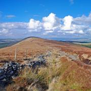
TERRAIN: 10+ field gates & stiles. Moderately strenuous walk. Woodland paths with trip hazards and slippery areas of exposed stone. Close proximity to river with areas prone to mud. Roadway without pavement. Livestock grazing.
REFRESHMENTS: The George, Alstonefield. Polly’s Cottage takeaway, Milldale (seasonal opening hours apply)
TOILETS: Public toilets at Alstonefield and Milldale
MAP O.S. Explorer OL24 (White Peak)
WALK HIGHLIGHT: The display of spring snowdrops

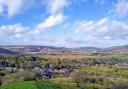
1: Make your way to The George Inn at Alstonefield to start this walk. The centre of the village is a maze of lanes around grassy triangle islands like a trio of village greens. Alstonefield is Saxon in origin, its name deriving from ‘Aelfstan’s open land’. Being on the route of many ancient tracks, it is known that markets were held here for a time from 1308 with cattle and horses being sold in the yard to the rear of the pub up until the first part of the 20th century.
Follow the signs to the 12th century church dedicated to St Peter, heading away from the front of The George along Church Street which is lined with old houses including the former rectory and manor house which has a date stone of 1587.
2: St Peter’s contains interesting features, including box pews with original brass work and the Cotton family pew which was painted green by a former vicar over a century ago. There is an unusual two-decker pulpit of 1637 while in the churchyard there are fragments of a 10th century cross shaft with interlace decoration, as well as one of the earliest recorded gravestones in the country which belongs to Anne Green, dated 3rd April 1518. A few yards away lies Margaret Barclay who died in 1731 aged 107! There have been three churches on this site, the earliest was built in 892, part of which is incorporated into the present structure, along with a Norman south doorway and chancel arch which are thought to date from around 1100.
3: Having walked past the church, continue on the road which now becomes Millway Lane. There are fabulous views in the distance of dramatic high banks towering above Dovedale which snakes south deep below.
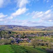
4: Arriving at the little cluster of characterful properties and quaint cottages that make up the village of Milldale, you will pass the tiny Primitive Methodist Chapel of 1835, where the occasional service is still held by candlelight as there is no electricity in the building. This is one of the houses of worship featured on the Peak Pilgrimage long distance walk.
The old 18th century mill at the heart of Milldale was demolished long ago, an abandoned millstone on the river bank now providing a useful perch for resident ducks. However, one of its outbuildings serves as a National Trust information barn containing wonderful examples of wood carving, including a rather terrified-looking sheep being dunked in a sheepwash and a copy of The Compleat Angler, known worldwide as the fisherman’s bible.

5: Cross the quaint and quirky packhorse bridge, which has retained its cobbled approach and is protected as an ancient monument. Descending steeply on the opposite side is a path known as Hanson’s Toot which is thought to be the route taken in the 17th century by Izaak Walton on his first encounter with Dovedale when visiting his friend and fellow angler Charles Cotton. In those days the bridge lacked any sides as the parapet walls were added later, which led him to write: ‘What’s here, the sign of a bridge? Do you travel in wheelbarrows in the country? This bridge was made for nothing else – why a mouse can hardly go over it, tis not two fingers broad.’ Consequently it is known as Wheelbarrow Bridge or Viator’s Bridge after the name given to Izaak Walton in the book.
6: Follow the riverside path downstream watching out for dippers skimming the surface, diving and dancing with the crystal clear waters. A resident heron can often be seen eagerly scouring the depths for fish.
7: After passing the gaping mouths of Dove Holes, fashioned long ago by water swirling around and carving out these caves, you arrive at Ilam Rock and Pickering Tor, giant limestone structures that point to the heavens, their surfaces covered with lichens, climbing plants, creepers and ferns.
8: Cross the river using Ilam Rock footbridge and follow the footpath right now heading upstream. Ignore a footpath on the left for Ilam and continue to a wall stile following the fingerpost sign for Stanshope.
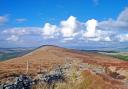
9: Ascend Hall Dale with a wall on your left beyond which is a vast tract of ancient woodland known as Hurt’s Wood. The final stretch of the path will cross fields and stiles leading to a grassy track. Turn left and walk to the road in front of Stanshope Hall where in early spring a glory of snowdrops can be found. The Hall, which dates back to the 1600s, is rather interestingly of dual aspect with a stone frontage onto the road and a brick frontage onto the orchard.
10: Walk to the right of Stanshope Hall along the lane with Church Farm on your right. This old way to Alstonefield will soon descend steeply to Dale Bottom.
11: Cross the road then ascend the bank opposite, if necessary using the signed alternative route to avoid a steep slope. At the top is a gate carved with Harry’s Bank.
12: Be guided by waymarker arrows and signs to cross fields and stiles back to Alstonefield, bearing left of the church along a path which eventually emerges conveniently close to the pub.