Wander for miles along tranquil paths over a scenic landscape fashioned by man through farming, quarrying, mining and mineral processing.
Route
1. Walk down Hawkhill Road and notice the line-up of Hall Hill troughs, part of a series of troughs established in 1558 to provide water for domestic and agricultural use. They are said to be one of the first such water supplies in the country.
At the junction turn right and walk up Main Road to Townhead. Along the way look for green information boards at the ruin of Bradshaw Hall which was a Tudor property and the Richard Furness House of 1615. See also West End Cottage where nine members of the Willson family perished and also Marshall Howe’s House. He was the village sexton and one of the few people who were infected by the plague and survived.

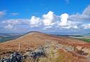
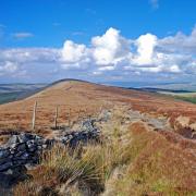
2. Turn left up Tideswell Lane and follow the byway to Housley, proceeding straight ahead where Windmill Lane branches off to the left. After passing the last of the properties look behind to see fabulous views towards Curbar Edge and White Edge away to the east.
This route soon becomes a walled track surrounded by fields enclosed by mile upon mile of dry stone walls consisting mainly of limestone, whilst away to your right the geology suddenly changes as Eyam Edge is gritstone. The tiny, white-painted building in the distance is the Barrel Inn at Bretton. See also the mast on Eyam Moor at the top of Sir William Hill.
You will notice lots of long strip fields either side of the track. Every so often there are narrow accommodation paths like grassy alleyways that provide access for farmers to reach their land.

3. Emerging at the side of the busy A623, it is approximately 225 yards beside the main road to the next public footpath. Keep to the grass verge on the right of the road and then carefully cross over to the fingerpost sign.
Alternatively, it is possible to turn right and walk around two sides of the triangle of quieter roads that make up the little settlement of Housley.
4. Proceed up the long straight track which leads to Burnt Heath and enjoy far-reaching views.

The area around Middleton Moor has become a well-known place in winter months where people come to observe massive numbers of starlings performing their impressive murmuration displays at dusk.
5. When heading towards the works at Cavendish Mill, aim to the rear of dormer bungalows where a narrow path leads to a stile onto the road. Be aware that plant and machinery operate here so adhere to any warning signs.
Cavendish Mill is owned by British Fluorspar Limited which utilises reliable process technology to produce raw material solutions for the fluorochemical industry.

Cross over the road and follow the public footpath sign opposite which heads up beside a large black pipe. This is taking water and waste sludge from the processing plant to holding ponds known as lagoons where, over a long period of many years, the silt and water separate.
6. Turn left at a footpath sign leading to Black Harry Lane. Black Harry was an 18th-century highwayman who regularly patrolled the primitive roads hereabouts, robbing pack-mule trains between Tideswell and Bakewell. A law had been passed imposing the death penalty for anyone found armed and disguised on high roads, open heath or moorland who was intent on robbery. Black Harry’s ‘stand and deliver’ days ended when he was apprehended at Wardlow Cop by the Castleton Bow Street Runners, resulting in his being hanged and his remains displayed on the gibbet at Wardlow Mires.
7. Turn right and descend this fabulous old path which at times has eroded down to slabs of exposed limestone bedrock. Two hundred or so years ago this was the main road to Eyam and was used by carriages, carts, pack ponies and hawkers. It could even have been along this route back in 1665 that the notorious flea-infested bolt of cloth travelled, on its way to be delivered to George Viccars, that resulted in the outbreak of bubonic plague which set Eyam firmly on the visitor map as a place of pilgrimage for future generations.

All around you is a working landscape – whether farmed, quarried, mined or processed – yet it is still possible in spring to hear the sounds of songbirds, skylark and curlew.
8. Arriving at a crossroads of paths at Black Harry Gate, turn left down Coombs Dale following the sign for a concessionary bridleway and descend into a tucked-away haven of peace and tranquillity known for its wild flowers and butterflies.

A natural spring emerges which at times floods the path with a shallow watercourse. This then joins forces with water flowing from a sough out of Sallet Hole Mine. The mine was still operating toward the end of the last century when some 200,000 tons of fluorspar a year were extracted, although originally it was worked for lead ore. Mines were often given unusual names and in the surrounding area there used to be the Strawberry Lees Vein, Old Ralph Vein and the Cackle Mackle Mine.
9. Continue down Coombs Dale beyond a footpath leading off on the right and then a large outcrop of rock where the brook changes from the right to the left-hand side of the road. Look for a large gate on the left with an arrow pointing to a stile hidden in the hedgerow.
Head up through the blackthorn and bramble, ascending a narrow path out of Coombs Dale up a steep-sided grassy bank renowned for its wild flowers. Follow the footpath through a series of fields and narrow stiles.
10. Head past an old stone building to emerge onto High Street and turn right to descend what is reputedly the steepest high street in Britain.
11. When you arrive at the Moon Inn carefully cross over the main road and walk along The Nook to a junction, with the church away to your right. Continue ahead and uphill to the left, ascending The Bank with its characterful houses and cottages. Turn right up to The Fold and then bear left up Cliff Bottom to follow Mill Lane back to Eyam.
12. Enter Eyam by walking down past a small stone-walled compound which contains the plague graves of George Darby and his daughter Mary.
Walk across The Square and turn left. Proceed up Church Street passing St Lawrence’s Church, Plague Cottage and Eyam Hall before returning to the car park.
Compass points
Distance: 8 miles
Parking: Both free and pay & display car parks can be found on Hawkhill Road, Eyam S32 5QP (opposite Eyam Museum)
Terrain: 6 gates, 8 stiles. Roadway without pavement including a short stretch of grass verge beside the A623. Livestock grazing in fields. Footpath through works where plant and vehicles may be operating. Narrow path up steep grassy bank in Coombs Dale.
Refreshments: Pub, fish and chip shop, Stoney Middleton; Pub & tearooms, Eyam
Toilets: Public toilets in the pay & display car park, Eyam
Map: O.S. Explorer OL24 (White Peak)
Walk highlight: Easy walking along miles of old trackways
Description: This walk offers panoramic views over a counterpane of fields, open land and wooded dale where birds flit and wild flowers flourish. Walk through Eyam to discover its historic past. More up-to-date is a brief encounter with the busy main road and a little oasis of surviving Peak District industry.