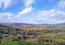
Elevated and exposed to the elements, the linear village of Flagg – thought to have been established by the Vikings – is surrounded by a cobweb of paths, tracks and green lanes. Sally Mosley thought a bracing hike across these White Peak uplands a perfect way to start the New Year
Distance: 8 miles
Parking: Hurdlow car park, High Peak Trail SK17 9QJ (pay & display)
Terrain: There are 12 stiles and three gates. This is an easy-going hike following tracks, paths and some field and stile walking with a short section of road without pavement. There may be livestock grazing in fields.
Refreshments: The Royal Oak, Hurdlow; The Bull i’ th’ Thorn beside the A515
")
Toilets: There are no public toilets on route
Map: OS Explorer OL24 – White Peak
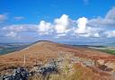
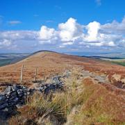
Walk highlight: Panoramic views from Highstool Lane
Description: These limestone hills are a photographer’s paradise when sprinkled with snow, dusted with a hoar-frost or illuminated by winter sunshine. Prepare to be surrounded by a patchwork of fields enclosed by mile upon mile of painstakingly created drystone walls, extending as far as the eye can see.
1. Leave the car park close to the entrance, passing through a gate and heading along the High Peak Trail beyond the white-painted former station masters house. Hurdlow Station first opened in 1833 on the Cromford & High Peak railway line. In some timetables it was listed as ‘Hurdlow for Longnor & Monyash’ although confusingly the O.S. map states this to be Sparklow. For over a mile the trail runs parallel with the A515, sections of which follow the course of a Roman road.
2. Continue to the end of the trail, arriving at a gate before the large Dowlow quarry complex owned by Omya. The stone extracted here is carboniferous limestone over 180 million years old and chemically a very pure form of calcium carbonate. This sedimentary rock was created from the compressed skeletons of zillions of prehistoric animals and sea creatures. Turn right and follow the fingerpost for Chee Dale along a stretch of the Pennine Bridleway. On meeting the main road turn right and walk along the protected roadside path then with extreme care, cross over the main road.
3. At the entrance to Blinder Lane notice the old round-topped parish boundary stone. Hartington was one of the largest parishes in the country, so large that it was divided into four Quarters. This stone stands at the boundary of Upper and Middle Hartington Quarters.
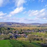
4. After Blinder House, turn right onto Highstool Lane at the PBW waymarker. This elevated track provides panoramic views over the High Peak hills to the north and White Peak hills to the south.
5. Towards the end of the track, notice Calton Hill topped by Chelmorton Low off which runs a little stream known as Illy Willy Water. It fills a series of troughs in the village which was Chelmorton’s only supply until mains water was piped from Ladybower. You will reach a crossroads known as Chelmorton Thorn, named after an ancient tradition of planting a thorn tree at a crossing of old ways.
6. Turn right and walk beside the road a short distance to a step stile with wooden bar on the right. Follow the footpath across fields and stiles, eventually walking between Town Head Farm and High Stool Farm to emerge onto Pasture Lane at Flagg. Notice in the last field the lumpy bumpy grass mounds. Flagg is surrounded by old shafts, remnants of lead mining that was a popular and profitable industry hereabouts during the 18th and 19th centuries, although its origin is much earlier. It is known that lead was mined in Derbyshire by the Romans who called it plumbum.
7. Cross the lane to a stile and then head over several fields bringing you to the main road through Flagg, and close to a long white-painted house behind a beech hedge. Looking around it is not surprising that at one time the Peak Dry Stone Walling Contest was held around Flagg every three years. In August 1938 a dilapidated old wall close to Back o’ th’ Hill Farm was pulled down and together with some new stone, was the setting for the competition. Competitors had to erect four and a half yards of wall to a height of 57 inches between the hours of 10am and 5pm. It is estimated that a skilled waller can build seven yards of wall in a day. To judge the walls, marks were awarded and a distinguished visitor would be invited to present the prizes. On this particular occasion, the remark was made, ‘If the walls of Jericho had been built by these competitors, they would not have fallen at the sound of the trumpet!’
8. Walk down to the junction and notice Flagg Nursery with its lovely play area and pencil fencing. See also the tiny village green with bus shelter, phone box and post box. Opposite is Flagg Hall, a traditional working dairy farm. The building dates back to the 16th century and has been home in the past to the Dales and Fynnes families. However the most noted resident of Flagg Hall is a ‘haunted skull’ which is still said to be contained within. Legend has it that should this skull be removed or buried, great misfortune will befall the owners of the Hall. An attempt was made to bury it at Chelmorton many years ago but when the funeral cortege neared the village the horses refused to proceed and despite any encouragement by the coachman, they became so agitated that he was forced to return to the Hall where the skull was replaced.
9. Turn right and follow Mycock Lane, walking beyond the bottle banks and along the drive leading to Knotlow Farm. You are now following a short section of the Limestone Way, part of a long distance route from Castleton to Rocester. After the cattle grid and beyond the avenue of young trees, keep to the wall side on the right and head to a small gate in the corner. Follow the footpath across two further fields to a walled path and then continue to a junction of tracks by an old disused farm building.
10. Turn right and walk up the grassy track known as Hutmoor Butts between fields where large flocks of birds often congregate and murmurate. You will pass The Derbyshire Centre, premises belonging to The Donkey Sanctuary, a charity based in Sidmouth, Devon. It is run entirely on donations which are carefully spent providing sanctuary for donkeys in need. It is open to visitors on the first Sunday of the month from April to September.
11. You arrive back at the main road by the side of the Bull i’ th’ Thorn Inn which claims to date from 1472 and is reputedly one of the most haunted hotels in the Peak District. The old sign above the door is carved in solid oak and depicts a bull entangled in a thorn bush. The custom of naming inns and public houses dates back centuries. The law demanded that any hostelry selling a new brew should project a pole from the wall of the alehouse so that the authorities were aware and could make checks. As alehouses multiplied it became necessary for them to be identified in some way, and so the custom began of hanging a sign from the pole with a name. Some of the oldest names contained references to the Sun, Moon and Stars, later many animal names were used.
12. Carefully cross the main road to a gate and follow the footpath across a field and then diagonally left, aiming for a tunnel beneath the former railway line where a little gate provides access to a path leading back up onto the trail with a short walk to return to the car park.