From Robin Hood’s Stoop to Little John’s grave, Sally Mosley takes us on an adventure-packed walk that ascends high above Hathersage for far-reaching views, passing a wealth of country houses along the way Photographs by Sally Mosley
This walk was published in February 2018, so the details of the route may no longer be accurate, we do advise these articles should only be used as a guideline for any potential route you take and you should double check an up to date map before you set off.
DISTANCE 6 miles

PARKING Oddfellows Road, Hathersage S32 1DD (pay & display) Grid Ref: 232812
TERRAIN 10+ stiles and gates. Moderate walk. Quiet country lanes without pavements. Field and stile footpaths where livestock graze. Electric fencing. Trip hazards in woodland. Very close proximity to deep water along riverside path. Areas prone to mud in wet weather.
REFRESHMENTS Various shops, tearooms, cafés and pubs in Hathersage
TOILETS No public toilets in Hathersage other than pubs and cafés for customer use.

MAP O.S. Explorer OL1 - Dark Peak; O.S. Explorer OL24 - White Peak
WALK HIGHLIGHT Panoramic views
DESCRIPTION This delightful walk is probably best undertaken after a spell of dry weather or a night of hard frost to avoid the worst mud. Do not walk the riverside path when the Derwent is in flood. Leaving Hathersage, the route ascends past Hazelford, followed by a switchback hike to Highlow and Offerton then a gentle descent through fields returning to river level. It ends with a stretch of the Derwent Valley Heritage Way for a tantalising glimpse of Nether Hall from the riverside path. All along the route there are magical panoramic views of faraway landmarks, moors and meadows.

THE WALK
1. Exit the car park in the bottom right corner, following a cut through behind the fire station and beside the Methodist Church. Emerging onto Main Road, turn left and walk down to the junction with a triple lamp stand which displays various signs. One points the way to the Open Air Swimming Pool (for winter opening days and times see www.hathersageswimmingpool.co.uk, which was constructed in the 1930s - as well as the bowling green, bandstand and other village amenities - thanks to the generosity of local businessman and philanthropist George Lawrence.
2. Turn left and cross the road to head down Mill Lane at the side of the Little John pub. Notice a brick chimney and old buildings, evidence of Hathersage's industrial past. Long ago the village was a manufacturing hub with various mills powered by the force of the water pouring down off the hills. These produced cotton, buttons and wire to make needles and sieves - a metal-working process introduced in 1566 by Christopher Schutz from Germany.

Walk under the viaduct. Its many arches span both the road and Hood Brook, carrying trains on the Hope Valley railway line. Follow the road around the left-hand bend and continue to a lodge which has a date stone for 1873 and sits beside the drive to Nether Hall.
3. Go over the wall stile to the left of the lodge and follow the fingerpost sign to Leadmill Bridge. Emerging onto a roadside pavement, turn right to cross over the bridge which was widened in 1928 to cater for the demands of modern day traffic. Ignore the first turn to the right and continue past the Plough Inn, which is on the opposite side of the road, and then to the end of a row of trees.

4. Turn right to walk up a narrow lane. Look back every once in a while at the views toward Millstone Edge and the high moorland that towers above Hathersage, which appears to snuggle down slowly into the valley as you rise higher. You will pass Hazelford Hall, a classical 17th century Derbyshire house. L-shaped, it has a porch, gables topped with ball finials and mullioned windows with fabulously ornate leaded glazing.
5. At a junction where the lane ascends steeply around a bend on the left, continue straight ahead going beyond the drive that leads down to Hog Hall and continuing past Torr Farm. After this the right of way becomes a grassy track followed by a footpath through fields and gates. The route then passes through a band of dense woodland leading you to a combination of paths and wooden plank bridges where you will also see a footpath sign for 'Via Stoke Ford to Abney'.
6. Turn right to cross Highlow Brook and go through a gate. Then head uphill, entering Highlow Wood on a path that is often carpeted with needles from larch, spruce and pine as well as leaves from beech, oak and sycamore trees. Continue uphill when you get to a field, using Highlow Hall as a beacon ahead to guide you, walking to the left of the garden wall with its impressive entrance and dovecote to a double gate which opens onto the road for Abney.
Highlow Hall was built in the late 16th century. A romantic-looking Elizabethan manor house, it is reputedly haunted by the White Lady and for centuries was owned by the Eyre family. In the 17th century it was home to Robert Eyre who reputedly acquired nearby houses or built new ones for each of his seven sons in positions where he could see them from the grassy knoll behind this Hall. The houses were Moorseats, Shatton, Nether Shatton, Hazelford, Offerton, Crookhill and North Lees.
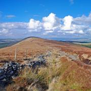
7. Turn right on the road to walk past old outbuildings now converted into a range of cottages and look for birds flying out of the woods and nearby trees to various feeders in the yard. Turn left off Abney Road and follow the narrow lane to Offerton which sweeps down to cross Dunge Brook before climbing again. Go past a drive leading down to Callow House Farm on the right and continue along the elevated road for yet more far-reaching views.
In a field to your left look for an upright former boundary stone mounted on a base. This is known as Robin Hood's Stoop. It is reputed to be the place from which Robin Hood shot an arrow into the churchyard of St Michael's on top of Camp Green in the oldest part of Hathersage - some 2,000 yards away! The churchyard is said to contain the final resting place of Little John who it is believed was over 7 feet tall, a true giant of a man in medieval times.
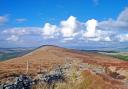
The extensive views ahead stretch to parts of the Hope Valley and encompass the Upper Derwent leading north beside Win Hill toward the grassy bank of Ladybower dam wall. Disappearing behind as you walk, the Derwent sweeps south on its long course through Derbyshire to join the Trent. In between you can see how Hathersage spread its wings following the arrival of the railway line, which can be traced by the regular appearance of colourful trains running through the valley.
8. Follow the road as its winds down past Offerton Hall which was mainly rebuilt in 1658 but stands on the site of a much earlier property said to have dated back to the 12th century. After passing the Hall and then Offerton House on the left go through a gate on the right by a footpath sign and walk downhill along a fenced-off path followed by a succession of fields and little gates to the river.
9. Do not cross over the stepping stones in the river but turn right and follow the sign for Leadmill Bridge and Hathersage on the riverside path, part of the 55-mile long Derwent Valley Heritage Way.
Be extremely careful as in parts the path is narrow and there are sheer drops into the river. At a bend you can see Nether Hall on the opposite bank. Built in 1840, it stands on the site of an old corn mill. The path later passes through Goose Nest Wood where Canada geese and mandarin ducks can sometimes be seen during the nesting season. The final section of riverside path passes through a meadow.
10. Turn left and follow the roadside pavement back into Hathersage, passing the David Mellor complex that comprises a design museum, shop, café and cutlery factory located in The Round Building, which was built in 1990 on the circular foundations of the redundant Hathersage gas works. Continue up the road and under the bridge to return to Oddfellows Road and the end of the walk.