
A farmland walk with SIMONE STANBROOK-BYRNE explores the historic village of Stogursey. If you don’t live in the area, this is one to save until restrictions are lifted!

1. In Stogursey, opposite the junction of Lime Street with High Street, a green and gold fingerpost near the war memorial gives guidance. Follow the direction for the castle, along High Street towards Castle Street, 20m away.
The walk heads down Castle Street, but before you get too dirty I suggest a brief diversion along High Street to the 11th century Priory Church of St Andrew. Between the 12th and 14th centuries monks from Lonlay, Normandy, had a priory here, sharing the church with the villagers; modern-day Stogursey is twinned with Lonlay d’Abbaye, maintaining that link.
Back on the walk, you soon pass the old pound on Castle Street, now a sometimes-open place to sit. Animal pounds were a feature of Medieval villages, being enclosures where stray animals were contained until reunited with their owners.
Beyond here Castle Street passes Pawlett Almshouses, originally founded in the 15th century to house ‘six poor people of the parish’. The bell was relocated from the original almshouses, which were rebuilt in 1821 and now house three people.

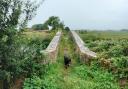
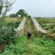
2. Continue another 100m down Castle Street to a raised footpath on the right, signed for the castle. Follow this; it soon reaches a cobbled footbridge with a small weir cascading below it. Ahead is the surviving lodge of Stogursey Castle, set within the ruins of the old curtain wall and surrounded by its moat.
The present castle remnants are on the site of a simpler 11th century fortification, which was remodelled over time by the de Courcy family. In 1210 Alice de Courcy welcomed King John to Stogursey Castle; the king is recorded to have lost 20 shillings to her husband, presumably gambling. Time and neglect have resulted in the ruins we see today.
However, the later gatehouse, built inside the gate towers of the castle, was rescued from encroaching vegetation by the Landmark Trust in 1981. It is now a unique holiday cottage.

Continue past the castle on the clear path, moat to the right, to reach a small stone footbridge going left. Cross, and go through a metal gate into a field. Walk through the field, boundary to the right, for 120m. Here a yellow-arrowed post gives options. Go left, crossing the middle of the field to another gate.
The path crosses a stream then continues clearly, soon passing corrugated Tet Hill Barn on the left. Keep straight ahead across the track and through the footpath gate on the far side, then continue through the next field beside the right-hand boundary.
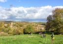
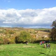
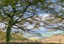
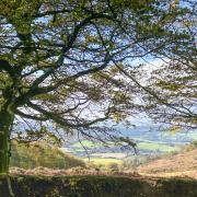
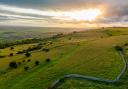
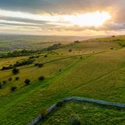
3. At the end of this field another gate leads into the next; from here, head obliquely right up through the middle of the next field, climbing Tet Hill. If you need a breather, pause to look back at views of Stogursey, with the massive construction cranes of Hinkley C dominating the view beyond.
The trodden path veers right to the summit, but that is not the footpath, which keeps in the same direction towards the far boundary and an arrowed gate. Beyond here, head down the field towards the extensive buildings of Peadon Farm; the heights of the Quantocks rise away
to the right.
At the bottom of the field pass through two gates in quick succession, then continue towards Peadon, along the right-hand hedge.
4. At the end of the field stay in it and veer left, walking with a large barn to your right. Beyond the barn, at the end of the field, bear right to leave the field and head across to a three-way fingerpost.
Go right from here, following its direction towards Nether Stowey along a surfaced track, soon passing the farmhouse on the left, various barns to the right.
Just beyond the house, attached to the end of a stone barn on the right, another fingerpost shows that Durborough is straight on, and this is your way, ahead along a hedged track away from Peadon.
As the track opens up, continue uphill beside the left-hand hedge. The path passes through a boundary into the next field, stay with the hedge. The buildings of Durborough Farm come into view and you drop down to a gate out of the field.
5. Follow the track beyond for about 20m, then turn right through another gate into a field. Now follow the right-hand boundary with a stream down in the ditch. At the end of the field is a wooden (and potentially slippery) plank bridge leading to a kissing gate. Go through, then continue beside the right-hand boundary, a small copse to your right, to reach another gate in 50m. After this turn left, keeping the hedge to your left.
At the end of the field go through another gate, its yellow arrow dotted with bullet holes, and continue beside the left hedge. Leave this field through a gate, cross the track beyond and continue beside the left hedge as an arrowed post directs.
At the end of this field a narrow path leads between brambles to a gate ahead. Ignore this gate, and instead go left, crossing a ditch, to an alternative gate leading into a field.
6. Follow the right-hand hedge, the arresting building of Stogursey Primary School, which has been glimpsed throughout the walk, is closer and clearer now. At the end of the field pass through two gates joined by a plank bridge, then continue beside the right-hand boundary towards the school,. This Victorian Gothic building was given to the village by Sir Peregrine Acland in 1860 as thanks for the recovery from illness of his daughter, Isabel.
At the end of the field turn left, still beside the right-hand boundary, and in 50m go right to leave the field through a gate, following an uphill track past the school. When you reach the road, cross over to join the pavement and turn right to walk back to the village centre.
7. The final stage of the walk passes historic homes with poetic names: Christmas Cottage, Diligence Cottage and Old Cross House. By the latter is what’s left of a Medieval stone cross, marking the market place of the Middle Ages. Head down adjacent St Andrew’s Road for 100m to find the cobbled path leading to the ancient holy spring. This was once the source of Stogursey’s potable water.
Back up to the High Street; your car awaits.
COMPASS POINTS
Map: OS Explorer 140 Quantock Hills & Bridgwater 1:25 000.
Start point / parking: The walk starts from High Street in Stogursey, where there is on-street parking. Nearby postcode: TA5 1TA. Grid ref: ST203428
Distance: 3.5 miles / 5.6km.
Exertion: Moderate, but, if muddy, strenuous!
Terrain: Field paths, which are muddy in wet weather, particularly around farms. Some road walking at start/finish. Wooden plank bridges slippery - caution.
Dog friendliness: No stiles, but there will be animals grazing. The route follows the road at the start and end, so take a lead. The Greyhound Inn welcomes dogs (check current Government guidelines on social distancing).