
Enjoy a walk on the southern edge of the Brendons and see historical highlights in a Somerset medieval market town

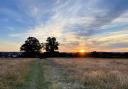
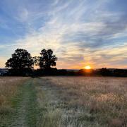
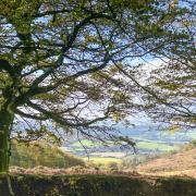
This pleasant route on the southern edge of the Brendons offers fine views of rolling hills, wooded valleys and patchwork fields. Using footpaths, bridleways and quiet country lanes, it has interest through the seasons, not least in spring with its wildflowers and new lambs. Watch out for wildlife too: I was fortunate to come upon a roe deer buck, whose curiosity overcame his fear, allowing me to approach, much closer than I expected he would permit, camera in hand.

Allow extra time to explore Wiveliscombe. A medieval market town with a medley of historic buildings, mainly Georgian and Victorian, Wiveliscombe is centred on its square. Its name, like most Somerset settlement names, is Anglo-Saxon in origin. It was recorded as Wifelescumb in 854, a name which signifies the combe (valley) of a man called Wifel,
St Andrew’s Church is worth adding to the walk. The present, handsome red sandstone structure, with Hamstone dressings, replaced the medieval church on the same site in 1829. It has box pews, a 14th century font and the alabaster Wyndham memorial of 1622.
Boots on? Let’s go…
1Turn right out of the signed car park in North Street. Follow the road past the school. Turn right into Northgate. Turn left into the signed public footpath between a house and a wall, just 20m before reaching a T junction.
2 Follow the enclosed path to a stile. Here, the footpath divides. Keep left. Cross a second stile and a field to a third stile. Continue ahead with the hedge on your left over two more stiles. Follow the enclosed path to a lane.
3Cross and continue ahead on the public footpath past a barn on the right. Continue with the hedge on your left. The path bends right. Go through a gate and follow the lane to a junction. Cross a stile and follow the public footpath downhill to a bridge. Follow the track uphill for 250m. Turn left up steps and immediately right over a stile onto the signed public footpath. Now facing west, cross the field ahead to a gate. Walk across the next field and over a stile. Continue past a house to a lane.
4Turn left, then right after only 30m. Follow the lane past Chorley’s Farmhouse. Turn right over a stile and cross the large field ahead to another stile. Cross a small field to a gate. Continue along a short enclosed path. Turn right and follow the right field edge to a barn. Continue following the right field edge to a stile. Exit by a gate at the end of the next field. Turn left onto the lane and almost immediately right and uphill.
5Turn right opposite Maundown Farm. Follow the lane uphill to a junction. Fork left onto the signed public bridleway. This is Jews Lane, which is said to take its name from the Jew or Jewe family. They owned land in and around Wiveliscombe from at least the 15th century.
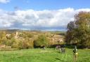
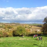
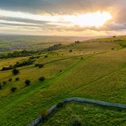
6When the path divides, keep left. Continue downhill, enjoying views over Wiveliscombe and the Vale of Taunton beyond. The town’s profile is dominated by two tall buildings. St Andrew’s characteristically Somerset red sandstone tower contrasts with the red brick malting tower and chimney on Golden Hill. These belong to the former Hancock’s brewery, which dates from 1807 and once employed half the town’s workforce. Closed in 1959, part of it is now occupied by the Exmoor Brewery, whilst Cotleigh Brewery is on the nearby industrial estate. Reaching North Street, turn right and walk past the school to the start, or continue for refreshments at one of Wiveliscombe’s inns or cafes.
Information
Distance: 7.4km (4 ¾ miles)
Time: 2 ½ hours
Exertion: Moderate
Suitable for: Dogs on leads and older children.
Maps: Ordnance Survey Explorer 128 or Landranger 181
Start: ST080279
Car Park: North Street
Terrain: Some ups and downs, but no long or arduous slopes. Signed paths and bridleways, but attention to directions needed. Parts muddy after rain.
Toilets: At start.
Refreshments: Choice of cafes and inns in Wiveliscombe.
Public transport: Number 25 Taunton/Dulverton route Mondays-Saturdays and Quantock Motor Services 10 Langley Marsh/Taunton route Mondays-Fridays. Traveline SW 0871 2002233 travelinesw.comRobert Hesketh is the author of: Shortish Walks on Exmoor; Exmoor Pub Walks; Really short Walks on Exmoor and Brendon; Shortish Walks The Levels and South Somerset; Shortish Walks Quantocks and Mendips. All published by Bossiney Books