It is hard to believe when you are standing in the beautiful Ball Grove Country Park that this was once the site of one of the largest light tannery in Europe. There is an information board in the car park with a picture of the buildings, which shows just how huge they were.
Colne was a major textile manufacturing centre in the 18th and 19th centuries but declined massively in the 20th and now little remains in actual textile manufacture other than the relics of mills.
Trawden, the small village this walk passes through, was also home to textile mills and one in particular, Hopkinson’s Black Carr Cotton Mill was immense. It is hard to imagine a building so large in such a small village and must have employed the whole population.
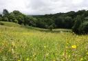
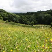
And while this walk takes in some of our industrial heritage sites, its main feature is the beauty of the Lancashire countryside which is dominated here by the brooding heights of Boulsworth Hill, wide-open moorland and stunning views. We’ll also see the Atom Panopticon, and the picturesque village of Wycoller.
The Atom is one of four panopticons, or viewing points, across Pennine Lancashire – the others are the Singing Ringing Tree at Burnley, The Halo at Haslingden and Colourfields in Blackburn’s Corporation Park.
1. Leave the car park down a path at the lower right-hand side and, at the pond, turn right. Follow the path as it makes its way past some houses on the right then turns left past the playground and down to the road, then turn left into Winewall Street and follow this uphill passing The Cotton Tree Inn on the left.
Reach a point where the road turns sharp left and at this point turn sharp right and follow the public bridleway where the road sign says ‘Hill Top’. After a graveyard on the left, the road forks, keep right and follow the tarmac road that eventually turns into a track. Stay on this until it reaches a road, then follow the road downhill to reach the main road going into Trawden. Turn left and pass the war memorial and the Trawden Arms.
2. Turn left then keep to the right and follow the cobbled track all the way up to join the main road, Lane House. This cobbled lane was part of the route of the Colne and Trawden Light Railway and near the top of the lane a section of the rail track is still in place.
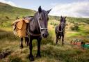
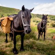
Turn left and keep following the road until it turns into a track that says ‘Boulsworth Lane’. Keep following the track as it eventually turns sharp left then passes Lodge Hill Farm on the right, then Mean Moss Farm on the left. Cross the cattle grid and a sign saying ‘Beaver Farm’. Keep on the track and pass, but do not go through, the entrance track to Beaver Farm on the right, keep following the track you are on to eventually reach and cross a cattle grid.
Note: Trawden is the home of Harry Walker, one of the best fell runners in the 1970s and early 1980s who won the British Fell Running Championships in 1973 and the famous Yorkshire Three Peaks three times in 1978-79-81. I am proud to have run in many races that Harry competed in, although I only saw him at the start and finish, in between he was a dot on the horizon miles ahead of me.
3. Join the Pendle Bridleway and turn left, following the track as it eventually goes downhill and crosses a bridge and now becomes the Pendle Way on the signposts. Keep on the track as goes through a couple of gates to reach a tarmac road then turn left to reach a sign that says ‘Pendle Bridleway Wycollar 1¼ miles’.

4. Turn left and cross a stile by a metal gate and follow the track downhill and reach a point where it joins a wide track with a house on the left. Immediately on the right is a footbridge, cross this and the stile on the opposite side and bear left, going uphill to a gate stile. Once over the stile, and with a house on the right, follow the path to reach a sign saying ‘To The Atom Concessionary Footpath’. Follow the footpath to a stile on the right and cross this and then turn left and cross another stile immediately after and follow the path uphill, crossing two more stiles to reach The Atom.
Note: The Atom was designed by Peter Meacock and Katarina Novomestska. It is an intriguing structure and offers stunning views through its circular portholes. There used to be a silver ball in the centre of the structure, but this has long since vanished.
5. Pass the Atom on the left and follow the path steeply downhill at first and keep on into some woods. When the path splits, take the left fork signed to ‘Hails Barn Toilets and Picnic Centre’. Reach this and turn right, passing the ruins of Wycoller Hall.

Note: Wycoller is a beautiful little village noted for its ancient bridges, of which the twin arched Packhorse bridge is the most famous. Wycoller Hall was the home of the Hartley family and was built in 1550 by Piers Hartley and was partially dismantled in 1818 then fell into ruin. It is thought to have been the inspiration for Ferndean Manor in Charlotte Brontë’s Jane Eyre.

6. Do not cross the ford or the packhorse bridge on the left but continue along the track to reach a track junction. Keep left and go downhill and cross a stile by a metal gate to join a track. Turn right and carry on to cross a metal gate stile and follow the path through a series of stiles to reach a stile in front and directly to the left is a stile. There is a Pendle Witch sign and yellow arrow. Cross the stile on the left and follow the path to reach and cross another stile and a footbridge. Cross this and the path becomes a track and follow this to reach Keighley Road.
7. Cross the road and cross a stile, then follow the path with Colne Water on the left and cross a footbridge over a stream. Carry on and cross a footbridge over the river then follow the path up some steps and then on to and across another footbridge. With the river back on the left, follow the path as it passes a pond on the right. Keep on until the path reaches a stile by a gate and cross this into a wide track then follow this and turn right and pass the Lakeside Café on the way back to the car park.
 OS maps")
COMPASS POINTS
START AND FINISH: Ball Grove Country Park car park, Colne, BB8 7HZ
DISTANCE: 7.8 miles/12.5km TIME: 4 hours
MAP: OS Map OL21 South Pennines
TERRAIN: Easy walking on tracks and footpaths, with a bit of road. Boots or walking shoes will be fine
FACILITIES: Public toilets in Ball Grove Park and Wycoller