Edward Griffiths explores an ancient coastal village and lagoon which was the setting for J. Meade Falkner’s thrilling smugglers’ tale Moonfleet

Distance: 4¾ miles (6.75km)

Time: 3½ hours

Exertion: Starts with an ascending lane out of Fleet. Easy descent to the Fleet’s Coast Path, then mostly level. Some mud patches after rain.
Start: Holy Trinity Church in Fleet (Grid Ref:SY634805). Take the ‘FLEET ¼’ turning off the B3157 in Chickerell. Park in designated area beyond the west tower. Donation requested.
Map: OS Landranger Sheet 194
Public Transport: None with suitable timings
Dogs: On leads in fields with livestock or where requested and on roads
Refreshments: ‘Dog-friendly’ Elm Tree Inn, Langton Herring, specialising in home-cooked local fish and real ales. Also Victoria Inn, B3157, Chickerell
***
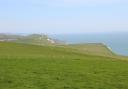
The Fleet Lagoon is almost eight miles long, starting from Portland Harbour at Ferrybridge and becoming less tidal and less salty towards Abbotsbury. The name ‘Fleet’ comes from the Saxon word ‘floet’ which describes a tidal inlet between the present-day Fleet village and Chesil Beach, probably from around 547AD.
In the time of Edward the Confessor, Fleet was owned by Earl Harold but, after 1066, it passed to one of William the Conqueror’s almoners. The Doomsday book lists Fleet as a royal estate with Holy Trinity Church under a priest called Rollo who also held land at Chickerell. In 1562, Queen Elizabeth I gave Fleet to Robert Freke and John Walker. Two years later, it went to Robert Mohun, whose descendants dominated the village until the mid-18th century. The church was probably rebuilt to house the Mohun family, but it was destroyed by the immense storm of 23 November 1824 when the sea breached Chesil beach and raged through the village. The present Moonfleet Manor, a handsome Georgian manor house, is named after the Mohuns and was their home. Today it is a lovely family-friendly hotel which serves up legendary afternoon teas.
Fleet subsequently passed by marriage to the Gould family. The Reverend George Gould built the new church where the walk starts.
The Walk
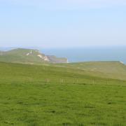
1 From the church gates, turn right up the long lane, passing right cottages and a footpath-sign. Up past left woods and right fields, and another footpath-sign, continue uphill with fine views along the Hardy Monument ridge. Reaching a junction with Sea Barn Farm left and a footpath straight on, turn right on the bridleway-drive. In 100 yards, at the West Fleet Holiday Farm notice, fork right onto the concrete track. When it bends left, keep straight on along the hedged bridleway-track - dead straight for over ½-mile with right views to coastal cliffs. Pass Bagwell Farm Touring Park left, and the right footpath which leads to the Victoria Inn. Continue up, cross the camp’s drive and follow the left fence to the two-way bridleway-sign on the B3157.
2 Turn left along the wide verge and into the enclosed bridleway-path left of the roadside hedge. Down into the narrow wood, turn left and follow the woodland bridleway-path for ¼ mile down alongside the stream. After the wood widens, continue to the T-junction and turn right up the steep rough track. In ¼ mile, emerging with right fields, follow the track round, past a bridleway-post, then along the wood’s edge and left hedge across the field. Straight into the fenced bridleway-track, continue into the yard and meander right/left between barns to join the orchard track. Go through 2½ bridleway-gates onto the drive to the lane into Langton Herring, signed back ‘Bridleway’.
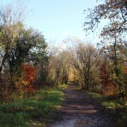
3 Turn left, but first, to visit St Peter’s Church turn right then left, or right then straight on for the Elm Tree Inn. Continuing the walk after turning left, go around the next right bend and take the left ‘Moonfleet 1¼’ footpath-track at Fleet Way Cottage. Through the end gate, follow the track up with fields either side and, over the top, with the Fleet and Portland left and views to Lyme Bay right. Descending, walk alongside the right wood and pass the left barn. At the wood’s end, pass the right footpath-post under an ancient yew. Keep straight on, passing footpaths for ‘Abbotsbury Coast Path’ right and ‘Bagwell Campsite’ left. At the next left ‘West Fleet’ Campsite’ footpath, go through the right wall and follow its other side, with the Fleet and Herbury Hill right.
4 At the end ‘Moonfleet and Ferrybridge’ signpost, go left into the field. From here, keep following the South West Coast Path, basically meandering through fields alongside the Fleet for 1½ miles. You’ll pass through a couple of thickets, with footbridges and boardwalks, pass Moonfleet Manor and Fast Horse Gallops and two World War II gun posts. After the 1½ miles, you reach a South West Coast Path ‘Ferrybridge 4¼’ milestone. Here, turn left for ‘Old Fleet Church’ up the field to the stream footbridge for ‘Chickerell ¾’. Over, follow the churchyard wall round to the kissing-gate to East Fleet’s Butter Street cottages. Visit the original Holy Trinity Church which was mostly destroyed in the storm of 1824. Then, continue along Butter Street to the lane. Turn left for ‘New Church and Parking’ and meander back to Holy Trinity Church, where you started.