Edward Griffiths enjoys a beautiful winter walk through Blackmore Vale following ancient tracks and taking in some fabulous views

Distance: 4½ miles (7.25km)

Time: 3 hours
Exertion: Fairly easy. Some mud after rain, especially in the downhill path through Ratcombe Wood
Start: Clock tower in the village centre where a plaque says that the village lighting was installed by subscription in tribute to those who served in the 1939-45 war. (Grid Ref: ST604132)
Map: OS Landranger Sheet 194
Public Transport: South West Coaches 74 and D14 except Sundays
Dogs: On leads in fields with livestock and on roads
Refreshments: The Lime Tree, Thornford an award-winning CAMRA Free House for lunches and real ale (‘Specials’ Tuesday to Saturday). Elwood’s Store for handy snacks and drinks.
-------------------------------------------------------------------------
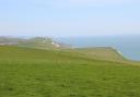
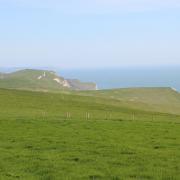
Situated in the top left-hand corner of the Blackmore Vale, Thornford is only ½ mile from the River Yeo and 4 miles ‘by crow’ to Yeovil in Somerset. But the village and its surrounding fields and shallow valleys are unmistakably ‘Dorset’, with clearly ancient tracks and gently sloping fields with pleasant views to the distant hills. St Mary Magdalene’s Church in Thornford dates from the 14th century, and hides itself away from the village centre.
From the start, we follow an ancient track and cross grassy fields to the neighbouring hamlet of Knighton before joining the Macmillan Way for a short stretch to equally attractive Lower and Upper Lillington. Here, a welcome south-facing bench, with views to Bubb Down Hill and Melbury Bubb, awaits you at 13th-century St Martin’s Church. Next door is Manor Farm’s stone-slated barn, built about 1600, with seven bays and twin porches. Most of the other stone-built houses here date from the 17th century as well.
-------------------------------------------------------------------------
The Walk
1 From the clock tower, walk down Longford Road and past Elwood’s Store. In 150 yards, take left Horsepool Lane. Past a right footpath-sign, continue into the hedged bridleway-track, without a sign. Before the facing gate, take the left-arrowed bridleway into the fenced path. Over the footbridge, pass a left footpath-gate and continue along the path, meandering through some old coppice with fields either side. Eventually, the path doubles back right over the stream. In another 100 yards, take the left footpath kissing-gate into a wide field with a right cattle-shed.
2 Cross half-right up into the tapering wooded corner, with Knighton Hill Copse left and Lower Wood right. Through the footpath-gate, follow the right wood to the gate. Through this, and the next, turn left along the hedge to the corner gate. Through this, go right to the footpath kissing-gate in the hedge. Through this, follow this clearly ancient path under the trees to Manor Farm, Knighton. Continue down the track to the road. Keep straight on up, past a left turn, past right Higher Knighton Farm and past a right footpath. Continue along the lane to a right bend. Here, go through the left gate with the two-way footpath pointer.
3 Bear half-right up the field, and go over footpath-stiles either side of the hedge, into the large field. Go straight across to the hedge’s footpath-stile just left of the solitary oak. Over this, keep straight across to footpath-stiles and sleeper-bridge in the hedge, 50 yards after the right gate. Over these, turn left down the very long field to the right footpath-pointered gate and stile onto the farm track. Cross Lower Farm’s drive and walk into the grassy clearing. Keep straight on, joining the tarmac lane, Lower Street, for ½ mile into Lower Lillington. Before the left stone barn, notice a bridleway half-gate. This is your way out, but visit St Martin’s Church and its bench first.
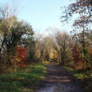
4 Through the half-gate we spotted earlier, follow the right hedge and continue up the hedged path, bending right-left under hazels, and negotiating another right-left, passing a left footpath-gate. Continue up the path under coppiced hazel, emerging at a right cottage into Higher Street, Upper Lillington, with a two-way bridleway-sign. Cross to the opposite gate into a rising field. Follow the right hedge to the bridleway-gate onto a track. Keep straight on, through the facing gate and along the left hedge to the corner 1½ gates. Through into the bramble and scrub path, start your (probably muddy) descent through Ratcombe Wood.
5 Down to a junction of paths, continue down to the right half-gate into the long field’s corner - not the left kissing-gate before the Millennium Seat. In the field, follow the left hedge down to the corner two-way bridleway half-gate. Through this, follow the hedged grass track. Passing between two pairs of gates, continue to a T-junction. Turn right. Reaching some houses, continue and emerge from Blacksmiths Lane into Pound Lane. Turn left. Past the village hall, turn right into Boot Lane. Continue to the T-junction and turn left, then right to visit St Mary Magdalene’s Church. Then, continue along Church Street, past the Old School and Coffee Tavern back to the village clock where you started.