Butterflies, buzzards and beautiful views sum up this lovely summer walk around Piddletrenthide and Plush Hill

Careful farming and maintenance of natural spaces has helped butterflies to thrive on this chalk hill farmland. You should see marbled whites, brimstones, gatekeepers, peacocks, red admirals and what Jill, a clearly knowledgeable Stour Valley Ranger I met a few years ago, identified instantly as ‘LBJs’ aka little brown jobs.
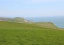
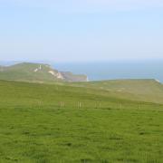
West Hill and Plush Hill offer magnificent views to the north as far as Duncliffe Hill and Win Green on the edge of Cranborne Chase, and Hardy Monument above Portesham in the south. If the long ascents find you wilting, feign fitness. Above you hungry buzzards may well be circling!
The Walk
1. Piddletrenthide is listed in the Domesday Book as paying tax for 30 hides, hence the name. Left of the Piddle Inn, take the signposted bridleway-path along the River Piddle and over the footbridge. Follow the track passing left barns. At left bridleway-gates, go around the right bend. Continue past two fine houses to the Cerne Abbas road. Turn left up the hill for 50 yards. Take the right bridleway-signed hedged path, then track with left fields and right gardens. After a left barn, drop down to pass the right lane and continue along the track past Malthouse Cottage. Keeping to the main track, pass more cottages and arrive at another lane, signed straight on ‘Bridleway’.

2. Go right, down the lane, passing The Barn and bending left. Visit All Saints’ Church with its magnificent 1487 tower, adorned with gargoyles, other strange animals and a sundial. Then, continue along Church Lane, passing lovely thatched cottages, to the B3143. Turn left, carefully for 100 yards to the right footpath-signed track. Through the gate, walk slowly up West Hill’s ancient sunken track, passing a chalk quarry. Before the top gate, take the left footpath-stile. Over into the large field, bear slightly right aiming for the top right end of the facing tree-line. Roughly 250 yards before those trees, veer off right to find the fence’s footpath-stile in the wildlife friendly field edge. Over, you should be between a left horse jump area and right cattle pens. Follow the green track along right trees down the field to a right hairpin.
3. Go over the facing footpath-stile/gate and follow the green farm track with terraces either side, then bending right down to a stile/gate. Over, join a sunken chalk track descending to 1½ gates onto the road. Turn left into ‘Plush’. Pass The Brace of Pheasants at the T-junction and turn right for ‘Hazelbury Bryan’. Follow the lane, passing the Old School House and bend left before rising past Millers Barn. Note the right footpath-gate. This is your route. But continue up the hill to visit St John the Baptist Church, designed by Benjamin Ferrey, a pupil of Augustus Pugin, in 1848. He designed the first villas in Bournemouth, in Westover Road, in 1837. The church was deconsecrated 30 years ago and restored in the 1990s as a concert space which is also home to the Plush Festival (plushfestival.com) taking place this year on 3 – 6 August and 14- 16 September.
4. Returning to that footpath-gate, go through and walk slowly up the angled track to the top zig-zag and fence footpath-stile. Over, turn half-left up the field, aiming 50 yards left of the top ash tree. Finding the hedge’s footpath-stile, go over and continue in the same direction over the huge field, aiming initially for the right end of the top clump before passing left of the concrete water tank. If not harvested yet, reach your target by following tractor tracks. Arriving at open ground, between top and lower woods, meet a bridleway-track descending outside the top wood. Turn right and follow the track along the left hedge. Keep following it, with a left hedge, no hedge, passing a left turn, and a right hedge.

5. Through the end gate, signed back ‘Bridleway’, cross the road and Doles Ash Farm drive. Follow the right hedge’s grass track down. Continue along wooden fenced section with Doles Ash Farm below you, and through trees and along grass track again with a right hedge. In 100 yards, take the right, hedged, unsigned, narrow bridleway-path. If the narrow path is deep mud, go over the fence section left of the path’s entrance and follow the right hedge to the end gate to rejoin the route. At the end, continue down the hedged grass track. Past a left barn, go up and over, and continue down to the B3143. Out of Tuttons Lane, turn right back to your starting point and the Piddle Inn.
Distance: 5¾ miles (9.25km)
Time: 4 hours
Exertion: Fairly strenuous on farm tracks and bridleways over hills and fields. Two fairly stiff ascents
Start: The Piddle Inn, Piddletrenthide. Park in Wightmans Orchard or nearby on B3143.
Grid Ref: SY907893.
Map: OS Landranger Sheet 194
Dogs: On leads on roads and in fields with livestock
Public Transport: Damory Coaches 307
Refreshments: The Piddle Inn or Brace of Pheasants for lunches