Edward Griffiths enjoys a bracing walk which offers sensational views across the Jurassic Coast
This exhilarating walk leads anti-clockwise around the Smedmore valley where Sir William Clavell built Smedmore House in the early 17th century. Sir William tried to bring prosperity to his bit of Dorset by producing alum which was used in the dyeing trade, but fell foul of patent problems. In 1615, he tried producing glass but broke an agreement confining sales to south-west England, and ended up for a while in Marshallsea debtors’ prison. Two centuries later in 1848, the Industrial Revolution came to Dorset when The Bituminous Shale Company started mining blackstone, a bituminous shale which could be burned for heat and light. But, with its evil smell, it soon fell out of favour. Ships took the shale to Weymouth for processing to produce pitch, paraffin wax, grease, dyes and naptha, although not enough of each to be viable.
Information
• Distance: 5 miles (8km)
• Time: 4½ hours
• Exertion: Strenuous. Several ascents, one very steep Permissive Path through gorse
• Start: Limestone Quarry near ‘Bradle’ T-junction on Kimmeridge Road (Grid Ref: ST918801)
• Map: OS Landranger Sheet 195
• Public Transport: Nothing suitable nearby
• Dogs: On leads at all times on this cliff top walk
• Refreshments: Clavell’s Restaurant, Kimmeridge for lunches and evening meals. The New Inn, Church Knowle for coffee and bar meals
The walk
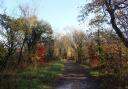
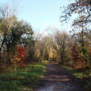
1. From the quarry, turn right up the road. Opposite the ‘Bradle’ turning, go over the ‘Kimmeridge ¼’ stile into the high field. Walk down the tree-bordered ‘valley and down to the footpath-gate left of the church. Down the stone path, leave by the gated steps, with Kimmeridge Farmhouse right, into Kimmeridge village. Continue down through the village, past the Museum of Jurassic Marine Life which houses Steve Etches’ world famous fossil collection, and past Clavell’s Restaurant. After the last right thatched cottage, with the ladder on the wall, take the right footpath-signed path alongside the garden. Over the stile into a field corner, walk down to the half-gated footbridge over the stream and turn left for ‘Kimmeridge and Coast Path’ in the long field.
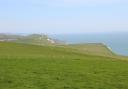
2. Follow the path along the left stream and bushes, and into a second field, and a third with the oil-field’s nodding donkey forward right. Exit at a ‘Kimmeridge ¾’ signpost onto the drive to the right oil-field. But turn left, passing another left footpath for ‘Kimmeridge ¾’, before turning right onto the track anti-clockwise around the car park to the cliff-top. The cottages were built in 1860 for bituminous shale miners. The chine is called Gaulter Gap, ‘gault’ being old English for grey clay. Follow the cliffs left, then pass a ‘Coast Path Chapman’s Pool 3¾’ stone. Through into a field, keep straight on, across another parking area and past left toilets. Turn right down the gated Tarmac drive for ‘Chapman’s Pool’, then take the left ‘Coast Path’ steps up through scrub, with increasingly stunning views, to Clavell Tower built in 1830 by Revd. John Clavell. Between 2006 and 2008 the Grade II listed folly and observatory was moved back from the crumbling cliff edge by the Landmark Trust, who now run it as a holiday let.
3. Past the tower and its original base, follow the Coast Path, keeping clear of crumbling cliff edges and recent landslips, for an undulating 1½ miles with some footbridges and steps. The rail-tracks you will see disappearing over the cliff edge are remnants of the War Department’s track for a moving target for vessels firing from the sea. Eventually, you will see Chapman’s Pool and St Aldhelm’s Head ahead as you descend to the left Permissive Path stile, signed ‘Swyre Head ¾’. Over this, follow the left banked hedge up the field. This field is always wet, and Paul Hyland suggests, in his book Purbeck, the Ingrained Island, that Rope Lake is a synonym for waterfall.
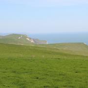
4. Keep ascending this ½ mile long field to the top corner Permissive Path (PP) half-gate. Through, walk up the fenced track. When it forks, continue into the PP-arrowed path, still against the left hedge, to another PP half-gate. Through, turn left along the track. In 20 yards, take the right PP half-gate into the field corner. Follow the right fence up steeply to the corner PP half-gate. Through follow the worn path, zig-zagging up the hill, with some steps and a couple of PP arrows, to the new Purbeck-stone wall’s PP-stile. Over, turn left along the wall, but first visit Swyre Head and admire the views from the Isle of Wight to the Isle of Portland, with Bournemouth, Poole and Weymouth between.
5. Past the OS trig point for 666ft, go through the bridleway half-gate into the first field. See Creech Hill barrow ahead, and Corfe Castle right. At the field’s end, go through Heaven’s Gate onto the fenced track with extensive views all around. Through the end gate into another field, just keep straight on against the left stone wall through more fields, fenced and unfenced, undulating and meandering until, suddenly it’s all downhill. Through a facing farm gate, continue down the stony farm track, passing an aerial mast and meeting the Bradle road. Turn left down to the T-junction and left again to the stone-quarry parking area where you started.
More…
• Christchurch blue plaque walk - Explore the history of Christchurch through its fascinating range of buildings on this easy town stroll