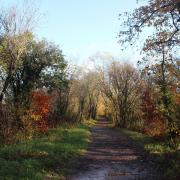
The late autumn sunshine reveals the contours of Cranborne Chase’s ancient barrows to Edward Griffiths on this atmospheric walk through history.
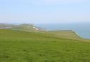
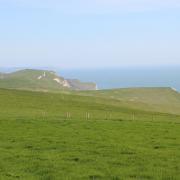
With the sun low in the sky, this is the perfect time of year to see clearly the low mounds and ridges of ancient barrows dotted around Cranborne Chase. In the first mile, we pass close by a Neolithic long-barrow. Then we walk along Ackling Dyke, the Roman Road between Badbury Rings and Old Sarum, through Oakley Down and Wyke Down - the most abundantly packed Bronze Age cemetery groups on the Chase. Local farmer and highly-regarded archaeologist Martin Green lives and works in this ancient landscape discover more about the history of this area in his book A Landscape Revealed. As you enjoy this fine walk, immerse yourself in the atmospheric landscape of Cranborne Chase, where our ancestors lived and toiled 3,500 years ago and where the Roman invaders marched nearly 2000 years ago.
Information
Distance: 6 miles (9.5 km).
Time: 4 hours.
Exertion: Not too strenuous, with some lane walking. Slow ascent along Ackling Dyke balanced by easy descent. Some mud in first fields after rain.
Start: St Mary’s Church, Sixpenny Handley (Grid Ref: ST995173).
Map: OS Landranger Sheet 184.
Public Transport: Wilts and Dorset 134, 184.
Dogs: On leads in fields with livestock and on roads.
Refreshments: The Roebuck Inn, Sixpenny Handley for teas, coffee and homemade cakes. Hanlega’s Restaurant in Church Farm Caravan Park for occasional lunch/dinner.
The walk
1 Walk through St Mary’s churchyard and leave via the back gate onto a track. Turn right into Church Farm’s camping field. Turn left through the field with play equipment at the far end to the footpath-gate in the right hedge. Through here, go half-left across this field to the facing gate where take the hedged/fenced path left of the gate. Reaching a field, bear half-right across to the fence’s footpath-stile. Over this, continue diagonally across this field to the footpath-stile onto a road. Cross over into Oakley Lane. Walk up past left houses and into the hedged track, gently rising and swinging right to a bridleway and footpath signed gate.
2 Through this, follow the bridleway grass track against the left hedge, then continue along the clear grass path up the huge field, swinging left, with long left views, then with pine-clad Pentridge Hill ahead and Wor Barrow on the right crest. Through the fence gap between twin pines, cross the drive onto the grass bridleway-track alongside the long left hedge, starting right of Chase Cottage. Oakley Down Barrows appear over the road to your right, with Whitey Top hill and Pentridge Hill ahead. Past another left opening and a narrow right wood, continue along the grass track, rising and bending right at the end to the bridleway half-gate onto the A354 Salisbury road.
3 Carefully cross, and go left of Yew Tree Garage’s workshop to the bridleway half-gate. Follow the left fence over Ackling Dyke Roman Road, passing the footpath-stile on top. Down into the field, turn right along the Dyke’s edge for 250 yards to the fence footpath-stile. Over this, turn left along Ackling Dyke. Pass the left field’s corner bridleway-gate and the left wood, and follow the footpath alongside then up onto the Roman Road. There are several barrows in the right field. Over the Dyke-top footpath-stile, you’ll see the largest disc-barrow of the Oakley Down group where, showing scant regard to history, the Romans built the Ackling Dyke road straight across one edge of the barrow There are more barrows where the crossing track from the left field cuts through the Dyke.
4 Over another Dyke-top footpath-stile, stay on or alongside the Dyke for another ½ mile. Over the end ‘bridleway’ stile, cross the B3081 left to 1½ gates onto the bridleway alongside Ackling Dyke with more barrows right. There’s more scrub on the Dyke now - but the path is descending. In ¾ mile, go through the facing 1½ gates into a wooded clearing. The angled wood’s edge follows the line of the ancient Dorset Cursus so, as you keep following Ackling Dyke’s bridleway track with the wood left, the point where the Romans cut through the Cursus must be nearby. In ¼ mile, at the bridleway and footpath crossing, take the right footpath into the adjacent Wyke Down field. Cross to the fence and follow it across the huge field to and past the round barrow.
5 At a hawthorn bush with old marker stones, the fence bends left. Keep following it. Around the left corner bend, with another marker stone, follow the short fenced grass track to a gate with left waterworks. Onto the road, turn right to the A354. Carefully cross into the Sixpenny Handley road for an easy one-mile stroll back to the village. The road swings left at Manor Farm and Sixpenny Brewery and shop. Pass a right turning, and right Frogmore Lane. In another 200 yards, take the right footpath-signed path alongside the left field, up between houses and along Littlefield Lane into Sixpenny Handley, emerging opposite the Roebuck Inn. Turn left and walk up through the village back to St Mary’s.
More…
- The ultimate Dorset walking guide - our complete guide of amazing walks all around the county
- The best autumn walks in Dorset - great walks to enjoy the falling leaves and changing colours