John Lenehan’s Watering Hole Walk takes him to Holcombe Moor with stunning views and a welcoming pub

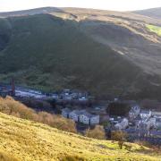
This is a lovely short walk on Holcombe Moor with splendid views and a memorial tower. What’s more, it has one of the most walker friendly pubs I know.
The centre-piece of the hike is the Peel Tower, which stands at 1100 ft on Holcombe Hill. The tower is 128 ft high and was built in 1852 as a memorial to Sir Robert Peel who was born in 1788 in Ramsbottom, the town at the foot of the hill. He was twice Prime Minister of Great Britain and is famous for creating the Metropolitan Police force. The term Bobbies we use for police officers is a derivative of his name.
1. Leave the car park and directly opposite there is a lane leaving the road diagonally right called Moor Road. Follow this uphill to where it forks and take the left fork still going uphill. Keep going left towards Peel Tower now appearing on the horizon.

2. A stonewall appears coming up from the left then turns to follow the track. Directly opposite the wall corner on the right is a small path, take this and follow this over open moor past an old quarry on the right.
3. The path reaches a wide main path leading from Peel Tower on the left and Harcles Hill on the right. Cross this and carry straight on.

Note: This area of the moors was once on the route of the pilgrims who would take making their way to Whalley Abbey in the Ribble Valley. On the opposite side of Harcles Hill are the remains of a stone cross that would guide them.
4. The path reaches the top of a dry gully going down hill on the left and splits. Follow the path that goes left and with the gully on the right follow this steeply downhill and then keep bearing left as the path leaves the gully.

5. The path joins a main track at a ruined building. Turn left and follow the track uphill going over two stiles by gates on the track and reaching a short cobbled section at a gate. Go through the gate and pass some houses on the right with a stonewall on the left.
Note: The area to the right of the track is an army firing range. You will notice warning signs telling when it is in use. This range was used for the assault course challenge in the television programme The Krypton Factor.
6. At the end of the stonewall where it turns left up on to the moor there is a stile on the left between two Hawthorn trees. Cross the stile and turn immediately right. The path parallels the main track before turning left and then climbs very steeply up to another stile.
7. Once over the stile, cross the wide track then carry straight on towards Peel Tower passing a bench with a memorial plaque.
Note: The bench was commissioned by the people of Holcombe to commemorate the year 2000 Millennium. It was produced two local men, Lee Ratcliffe of Stubbins and Simon Nuttall.
8. The path leads to the front entrance of the magnificent Holcombe Tower. The views are stunning over the Rossendale moors and out as far as the Peak District.
Note: The Peel Tower is sometimes open to visitors wishing to climb the 150 steps to the top. For details ring 0161 2535353.
9. Retrace the route past the Millennium bench but on joining the main track turn left and follow this down hill and eventually it joins a concrete road. Turn left and follow this to the junction of Holcombe Old Road and Cross Lane. Turn left and follow Cross Lane to the Shoulder of Mutton.
WATERING HOLE
The Shoulder of Mutton has got to be one of the most walker friendly pubs. The pub offers to walking clubs or groups a great package. If the group contacts the pub with the date and time of arrival - preferably morning - the manager and staff will allocate a section of the car park and block park your cars. They then offer modestly charged bacon and sausage butties or breakfasts, tea or coffee that you can pre-order when arranging the car parking. There is nothing better to start a walk than bacon butties in my opinion. They can provide sandwiches and if you tell them the walk and the estimated time it will take, they will have lunch ready on your return. All this and real ale!
COMPASS POINTS
Start and Finish: The Shoulder of Mutton, Holcombe Village, Ramsbottom, BL8 4LZ. Tel: 01706 822001: Email: info@theshoulderofmutton.net
Terrain: Mainly good tracks except when crossing the moor, here the walk is on a narrow path over grass. There are two steep climbs and one descent and in wet conditions the moor can be boggy.
Distance: 2.75 Miles/ 4.45 Km
Map: OS Explorer 287 West Pennine Moors
Facilities: Toilets and food in Shoulder of Mutton. No public toilets or food on route.


