John Lenehan leaves his map at home and takes us on a guided walk around the historic village of Whalley

This walk was published in March 2019, so the details of the route may no longer be accurate, we do advise these articles should only be used as a guideline for any potential route you take and you should double check an up to date map before you set off.
This particular walk is a first for me as I am following someone else's route. The Heritage Trail is a walk around the pretty, bustling village of Whalley and visits some of the interesting historic sites there. The map was designed to commemorate the centenary of World War One and includes visits to the four blue remembrance plaques in the village.

The map isn't printed here but it's available for £1 at Whalley Abbey, the village Post Office, the library, CJ's Sandwich Shop, a shop called Precious, The Dog Inn and Whalley Wines. The proceeds are used to raise money for the Royal British Legion Charity. The waymark numbers I have used are printed on the map and are not numerically the order of the trail.
Blue Circle 1 on the map
Leave the bus station and turn right towards the zebra crossing and on the right is the pretty Vale Gardens with the three fishes metal sculpture and a blue plaque commemorating the people of Whalley in World War One. Cross the road and turn left and walk down King Street towards the bridge over the River Calder.
Note: The huge hill of Whalley Nab dominates this end of King Street but is actually in Billington and Great Harwood.
Blue Circle 3
On the wall of 5 King Street is the plaque to soldier and sportman Leonard Green. In the window there is a poster telling his life story. It is worth continuing to the bridge over the Calder to see the viaduct and the Whalley Hydro.
Note: A slight diversion takes us up the small street of Calder Vale on the left just before the bridge to the weir, probably built by the monks of Whalley Abbey. On the opposite side of King Street there is Abbey Mews. Walk up the street and turn right into the courtyard of Corn Mill Mews and the waterwheel can be seen behind some railings. There is a plaque on the wall giving the history of the mill.
Red Circle 1
St Mary's and All Saints Church. Return up King Street then at the De Lacy Arms turn left into Church Lane, the oldest street in the village. The church is on the left. Note: The majority of the present church dates back to the 13th century but there are three Anglo Saxon crosses in the churchyard so there is a strong possibility that there was a much earlier church on this spot.
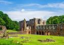
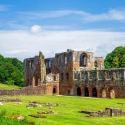
Carry on along Church Lane past the primary school and turn left down The Square to the village's most impressive building, Whalley Abbey.
Note: The foundation stone for the former Cistercian Abbey was laid in 1296 by Henry de Lacy (hence the name of the pub on King Street) and lasted until the dissolution in 1537. Displays in the visitor centre show how splendid it was.
There are also many buildings in Whalley and some of the surrounding villages that have parts of the abbey stone work incorporated in them.
Red Circle 4
English Martyrs'Church: The Square gives way to The Sands. Follow this towards the very impressive ruined gatehouse building of the abbey and English Martyrs Church is on the left.
Note: The church was built in 1926 and is a very attractive mock Tudor building. The church is not generally open to the public but a visit to the churchyard to see the statues and stations of the cross should not be missed.
Some of the land behind the church used to be the orchard for the abbey.
Leave the church and carry on along the Sands now and through the gatehouse. The vaulted ceiling above the road is particularly impressive and note that pillars separate pedestrians and the road. It stands alone now but used to have buildings on either side. The road leaving the gatehouse is called Riddings Lane. Note: This is the North West gatehouse of the Abbey and the upper floor of the now roofless building was once the Grammar School.
Once through the gatehouse, follow the road under the Whalley Viaduct and turn right into Broad Lane, a single track road that was once actually a lot broader hence the name.
Note: Whalley Viaduct is one of the most impressive structures in Lancashire and is also the longest railway viaduct in the county. It has 48 arches and the two either side of Riddings Lane have been built in such a way to reflect the Abbey in the architecture. It took seven million bricks and they were all made on site of local clay.
At the end of Broad Lane turn left into Mitton Road and follow the road.
Blue Circle 2
Queen Mary Bridge. Here is a Blue WW1 remembrance plaque commemorating the site of Queen Mary's Military Hospital. Across the road is the site of Whalley War Memorial Garden that is actually a military cemetery with the graves of 42 war casualties.
Note: It is worth going to the plaque to learn a bit more about the hospital and there is a stile on the right of the bridge and just over this is a very interesting tree carving.
Return back down Mitton Road and carry on past the tennis courts and beyond them the cricket field, bowling green and football pitches. Pass Broad Lane and under the road arch of the viaduct. The railway station is on the left. Keep on what is now Station Road towards the village centre. Note: On the left are a row of unusual stone cottages. These are the Alms Houses originally for the poor of the village.
Carry on along Station Road to the roundabout and turn right into King Street.
Red Circles 5 and 6
These are The Old Grammar School and the War Memorial.
Note: The building stopped being a grammar school in 1908 but it dates back to 1725. It is now used as a pre-school and a community centre. The war memorial was the scene of a beautiful and moving ceremony to mark the centenary of the ending of the First World War One.
Blue Circle 4
Almost directly opposite the war memorial on the opposite side of King street is the 4th Blue Plaque of remembrance. This is for Colonel Alexander Hepburn Macklin, who won the Military Cross. Follow King Street back towards the Bus Station and start of the walk.
Note: The church you pass on the left is Whalley Methodist Church. The first Methododist chapel in the village was in Church Lane and consisted of the upper rooms of two cottages. From these humble beginnings the congregation grew and the present church was built in 1872. The church has a series of beautiful stained glass windows and one in particular is linked to World War One. The St Francis of Assisi window is dedicated to Francis Edward Davis who was killed in the war.
Compass points
Start/finish: Bus station in WhalleyDistance:
Distance:2.95 miles/4.7kms
Time: Two hours or more depending how much time you spend at the Abbey and the churches
Terrain: Very easy - it's all paths and pavements
Parking: Pay and display in the village centre
Refreshment: Spoilt for choice - everything from sandwiches at CJ's to the award winning Breda Murphy's
Toilets: In the village
Map: Bought in the village - see the text for details