Keith Carter describes a walk which begins and ends in lovely Worden Park
Leyland holds so many memories for me I hardly know where to start. When I came to work here in the late seventies it was thriving industrial town with Leyland Motors the largest employer, although I worked for a large conglomerate called BTR which owned two factories making belting, hose and rubber products. We used to claim, tongue-in-cheek, that we made ‘everything respectable in rubber’.
My lowly role was as a manager overseeing three shop-floor departments making products for the marine and aerospace industries and I marvel from this distance in time that, young and inexperienced as I was, I held the fates of hundreds of workers in my hands. I couldn’t do their jobs but had a sneaking suspicion any one of them could have done mine.
The truth was the factory was run by the foremen rather like the Army which is said to be run by the sergeants, with the officers there to do the paperwork. This was all a long time ago and they say the past is another country. It certainly feels like it. The buildings have long been reduced to rubble and the land used to build affordable homes.
Leyland is now much like many other English towns with multiples such as McDonalds, Tesco and Iceland much in evidence and industrial activity pushed out to the motorway edge-lands. Yet the surrounding countryside is still close by and you can soon find peace and solitude and spot a buzzard’s lazy flight within minutes of leaving the built-up area.
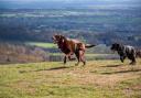
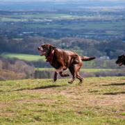
Worden Park has always been the town’s main lung, a paradise for dog-walkers with good facilities such as the coffee shop and the arts centre, ornamental gardens, a narrow-gauge railway in the summer and plenty of open space to fly kites and let the kids run about. The main car park off Worden Lane is free and this is where our walk begins.
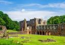
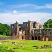
Walk into the park and turn right on reaching a lozenge-shaped pond. Follow the main path past the remains of Worden Hall where the arts centre and coffee shop are located. The hall proper burned down in a disastrous fire in 1941 and following the death of the last of the line of the Farington family the park passed into the hands of South Ribble Urban District Council who look after it rather well.
We proceed alongside a high wall and soon leave the park by an ornamental gate much in need of a coat of paint, the path continuing past a housing estate to reach Leyland Lane. Turn left, cross the road and at a roundabout cross Schleswig Way to what is now a redundant road much favoured for fly-tipping. Schleswig Way is named after Leyland’s twin town in Germany.
At the end of the neglected road, where it bears left, go through a gate and, after crossing a stream, turn left. This takes us through a gap to a field path with the sluggish stream of Mill Brook on our right.
We are heading for some buildings that turn out to be the water treatment works run by United Utilities. A path has been diverted to follow the perimeter fence round three sides before returning to the brook. The signs hereabouts have the website of the Homes and Communities Agency (HCA) which some Googling reveals is the national housing and regeneration agency for England with an annual budget of �5bn. Could this mean this area is earmarked for building houses?
Continue beside the brook through the next field and gradually widen the gap between you and the brook, making for a gateway. Turn left through the gateway and keep along the left hand boundary hedge and in the corner a second stile and plank bridge leads into an area of rough grass where another one of those HCA signs announces that this is private land except for the public footpath.
Carry on along the right hand hedge line to meet a gate at Brookfold Farm where a public footpath takes us through to Leyland Lane again. Turn left then immediate right onto Altcar Lane. Just past Cottage Farm take a lane on the right and before the gate to the beautifully restored Shrubsnape Farm take the stile on the left that diverts the footpath round the property. Opposite the gable end of the farmhouse take the stile into a field, following the left hand hedge, cross a second stile and then head diagonally right across the next field heading for a stile in the top corner.
Cross a further field to a gateway ahead where a tractor has created a prominent track alongside the hedge. This becomes a green lane at a metal gate and we pass through the yard of Bourne’s Farm where some cottages have been nicely restored using the red brick characteristic to this area. At the road, turn left and the Plough Inn is along on the right at the roadside.
This well-known establishment was formerly referred to by everyone as Jerry’s after the landlord at the time and even today some people still use the nickname. If you fancy a drink or lunch they serve food Monday to Saturday 11am to 9pm and Sundays noon to 8pm.
Our walk continues beyond the pub at a lane on the left, Tithe Barn Lane, leading to Altcar Farm where the smell and noise of clucking gives away the fact that this is a hen farm of considerable size. At the end of the lane take the stile immediately opposite and go right to pass a barn.
There is a stile in the corner of the barn and we cross it and keeping left, take a line that is parallel with the trees to the left where the land falls away to Shaw Brook. There is no way through the fence along the tree line and we have to negotiate two broad fields before reaching Worden Lane at a stile.
An alternative route back would be to cross the footbridge over the brook and walk back on ourselves through the wooded dell as far as the folly over Stannings Weir.
By taking the path on the right we find ourselves back in Worden Park with the pathways leading us back to where we started.
If you prefer a more direct way back, on reaching Worden Lane, go left and follow the pavement alongside the wall of the park and at the second entrance turn in to where we left the car.
Add your photos of Worden Park by clicking the red button below