This walk by Simone Stanbrook Byrne explores tracks and paths leading up onto Dartmoor National Park around Scoriton

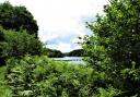
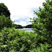
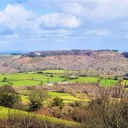
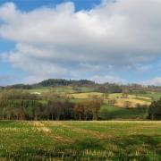
Dartmoor is one of Devon’s legion treasures. A place of vast skies and breathy heights; I can see it from my house 30 miles away, hear it calling me to get my boots on.
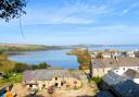
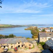
But it isn’t all expansive moorland and high tors; it is also a place of tiny hamlets and villages, sequestered gardens and fabulous old pubs; places where people have lived, worked and travelled for centuries.
This walk explores tracks and paths leading up onto the moor around Scoriton. It has the added enticement of two pubs offering toothsome refreshment (restrictions permitting): The Tradesman’s Arms in Scoriton, whose conservatory dining room is also something of a gallery for a local artist, and the ancient Church House Inn at Holne, a mile to the north. Holne also has the attraction of an excellent village shop selling artisan bread – and with luck their tea rooms may reopen during 2020.

If your timing is right you may also have the opportunity to visit the beautiful gardens of Greatcombe, near Holne (postcode: TQ13 7SP), which opens under the National Garden Scheme every year (again, this is dependent on the lifting of restrictions). They hope to be open 31 July-2 Aug, 1-5pm – but please check (ngs.org.uk) to confirm, if you intend to go.
So, find one of those serene, sun-splashed summer days and head out to Dartmoor, you will be well rewarded.
Note: a short section of the walk is on open moor, so if you have a GPS it may reassure – though the route-finding is not difficult. Clear weather needed.
Directions to start: Scoriton is three miles north-west of Buckfastleigh, accessed along small lanes from the A38
Parking and Start Point: Park on road in the village centre; alternatively, if you are planning to visit The Tradesman’s Arms for refreshment, they are happy for walkers to use their car park. Postcode: TQ11 0JB, Grid ref: SX704685
Map: OS Explorer OL28, Dartmoor 1:25 000. The OS map shows the spelling as Scorriton
Terrain: Tracks, field paths and some open moorland walking so a GPS may be handy; starts along quiet roads
Distance: 4 miles
Dog friendliness: Good but animals grazing and some quiet road walking. The Tradesman’s Arms welcomes dogs
Exertion: Moderate
Refreshments: (Covid-19 restrictions permitting) The Tradesman’s Arms , Scoriton, TQ11 0JB. Nearby Holne also has the option of a very good village community shop (whose tea rooms may reopen during 2020) and the Church House Inn , TQ13 7SJ
Route:
1. From the centre of Scoriton (spellings vary) walk downhill, passing an area of benches near the diminutive war memorial on the right, and a phone box on the left. Keep ahead on the road for almost 200m to reach Whitey Cross. Turn right here, a sign warns of a forthcoming narrow bridge. The road bends left and soon descends into the delightful hamlet of Combe. Cross Combe Bridge and turn right, the River Mardle is down to your right.
In another 70m, as the road bends sharp left, turn right along a no-through road to Higher Combe. You soon reach a cluster of houses with their notice board beneath a venerable, ivy-clad oak tree.
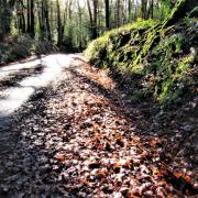
2. Go left here towards the wooden fingerpost near a house called Great Oak Cottage. Follow its direction towards Strole and Lud Gate along a rising track that soon bends right into gardens. Leave the track at this point and keep ahead along a narrower path, the trees of Lakemoor Wood are up to the left. This is an appealing old path, its flanks upholstered with moss and ferns; the way becomes increasingly wooded.
Keep going, the route is obvious and uphill. Eventually the path arrives at two gates, one ahead and one over to the left. A yellow arrow on a post directs towards the one on the left. Head for this and go through the adjacent arrowed footpath gate – watch out here as a chain is cunningly placed at ankle level, attaching the gate to its post, and a hazard to unwary walkers.
3. From here, walk up the field on the well-trodden path, woodland to the right (the footpath officially follows the line of the right-hand fence but the worn path is further in). In just over 100m the trodden path bends right near a tree with its branches resting on the ground and reaches a two-way fingerpost. Go left at the post, continuing uphill, now on a narrow path.
Unless it has been cleared, you will soon meet a substantial tree that has fallen across the path, its twin trunks splitting in either direction. Veer right, if necessary, then rejoin the footpath with an easy scramble over the bank. As you continue to climb, pause to enjoy views over your right shoulder towards Holne.
The path rises to enter a field through an arrowed gateway. Continue uphill through the field, the trees of Scae Wood down to the right. The path passes a water trough, still climbing, with increasing views behind. Towards the end of the field the path bends left, following the fence line round to meet an arrowed gate in the corner.
Beyond the gate follow the right-hand fence; the buildings of The Strole are visible. Stay beside the fence as it does a quick left then right, to reach a fingerpost in the field corner.
Go right as directed, passing through a gate with adjacent cartwheels. Turn left immediately after the gate and walk away from the buildings, arriving at a broad crossing track in 20m.
4. Turn right and follow this track for just over a third of a mile, passing an attractive and remote cottage just before arriving at Lud Gat (grid ref: SX684673).
Through the gate is a two-way fingerpost. Walk away from it, following the direction of the finger pointing obliquely right, which is signed for the bridleway to Scoriton via Chalk Ford. You are walking through sedge and gorse, approaching moorland. Over to the right a post and wire fence is visible.
Just over 100m from the fingerpost you join a clear grassy track which winds back in towards the right-hand fence.
If you like walking why not check out these 10 woodland walks in Devon?
5. The path bends right round a corner with thickets of gorse to the left, and crosses a damp area. The path divides after this but soon converges again.
Keep ahead through the gorse, still following the clear path and ignoring a right fork about 50m from the corner which heads towards the fence and a conifer plantation. Instead, stay on the broader grassy path, enjoying this downhill stretch across the moor, with the fence some way over to your right, for a further 160m.
At this point you find another right fork in the grassy path. Take this. Holne is visible away to the right. You are following the Two Moors Way, on a pleasing path down into the wooded valley; you may hear the busy waters of Snowdon Brook below.
6. Near the bottom the path starts to bend right and once more runs beside the right-hand fence. Walk round the fence corner and head across to the footbridge spanning the brook at the area of river shown on the map as Chalk Ford (grid ref: SX685681).
Cross the bridge; it may be slippery. There is a bridleway fingerpost on the far side and from here turn right, passing through a gate and following the track, uphill again for a while. The brook is down to the right; look out for green woodpeckers and, possibly, a hovering kestrel.
The track passes a host of tree tubes on the slopes down to the right, woodland of the future. A little further on, pass through two gates in quick succession, ignoring a permissive path that goes left, back up to Scoriton Down, and keeping ahead on the bridleway, passing the entrance to Scoriton Down Farm.
The bridleway widens at an area of field gates, bear left, still following the track downhill, and just over a mile from Chalk Ford you arrive back in the heart of Scoriton.
Simone Stanbrook-Byrne has written a selection of West Country guides including: Favourite Walks in Devon, Circular Walks in the South Hams, Circular Walks in East Devon, Circular Walks in Central Devon, Circular Walks in North Devon/Exmoor, A Dozen Dramatic Walks in Devon, Town Walks in Devon. culmvalleypublishing.co.uk/01392 881513
Ordnance Survey maps are available from all good booksellers and outdoor stores or visit their online shop for more.
Have you joined the Devon Life Facebook page yet?