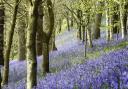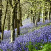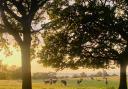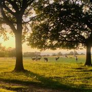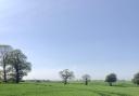

The Blean is a treat of woodland, countryside and villages situated between Canterbury and Faversham. You will follow the gently winding path of long gone drove ways through ancient woodland before entering open countryside offering fantastic views of the Medway estuary

Location: Herne Common, CT6 7JX
Distance: 3.5 miles (5.63 km) Circular
Time: Allow up 1.5 to 2 hours walking time
OS Explorer Map: 149
Terrain: The walk has stiles, bridges and some moderate gradients. The Blean is on heavy clay in places so can get wet and muddy – boots are recommended.
Public Transport: Bus stops are located near the First & Last pub. For public transport directions to Herne Common from your home address, please visit kentconnected.org
Parking: Parking may be available on Anemone Way near the First & Last Pub. Please park considerately.
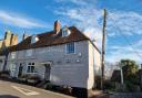
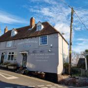
Refreshments & facilities: First and Last family pub at the start & end of your walk serves home cooked food and a range of beers.
The Blean is a treat of woodland, countryside and villages situated between Canterbury and Faversham. You will follow the gently winding path of long gone drove ways through ancient woodland before entering open countryside offering fantastic views of the Medway estuary. Discover the splendid Knockhimdown hill, the interesting field boundary of Bleanbottom Shaw and the old Blean Union workhouse that once housed ‘difficult women’.
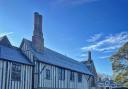
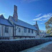
Beginning opposite the family friendly First and Last pub just outside Herne Village, look for the Herne hospital which previous to that was a workhouse (now a residential development). Built in 1835 without any outside windows on a four acre site, it was overseen by the Blean Poor Law Union which was formed in April 1835.
From here, you’ll start your walk by turning right out of Anemone Way. Walk along Canterbury Road to the junction with Bullockstone Road. Cross Bullockstone Road and turn right into Braggs Lane. Walk to the gate across the end of the lane which is marked ‘Bleangate’.
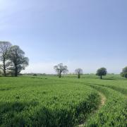
Cross the stile which is immediately to the left of the gate and continue straight on following the track for around 140 metres, where you will come to a turning on the right. You’ll be walking through a typical Kentish landscape of woodland, hedgerows and a gentle track leading onwards.
Take the path that turns to the right. You will now be entering into woodland and following the pathway of long gone drovers as they ‘drove’ their cattle from summer to winter pastures. The drove ways were surrounded by ditches which prevented animals from straying into the woods. They were also used to mark ownership boundaries as well as for local people to bring out timber and underwood.
After taking the path, continue for about 800 metres. Look for a marker post and turning on the right to continue on the path. In another 200 metres you will come to a wide track. Cross over the track and carry straight on through the earth banks of an old drove way. Continue onward for about another 90 metres towards some electricity pylons.
Walk under the pylons and then electricity poles to the junction with another public footpath marked by a post. Take care as the ground here is very uneven. The ground of the Blean consists of heavy clay due to large quantities of clay removed from nearby Stubbs Wood to fill the breach in sea defences during the great storm of 1953, which saw more than 1000 miles of British coastline affected. It was one of Britain’s worst peacetime disasters.
Turn right onto the path which follows the line of the poles. Cross the stile and continue straight across a flat open field, keeping the poles on your left for approximately 375 metres. Look out for an Old Pollard to the left of the stile, it is an ancient tree cut at or above head height to prevent animals from reaching new shoots. Centuries ago, they were also used to mark significant points such as parish or ownership boundaries.
Cross the stile or hurdle gate and walk under the electricity lines. Bear right and walk along the ridge. Keeping the boundary fence to your right, continue all the way to the corner of the field for approximately 425 metres. Look to your left to see panoramic views of Knockhimdown Hill. This is a great viewpoint, on a clear day you can see Sheppey and Essex beyond as well as the 30 wind turbines on the Kentish Flats Wind Farm in the Swale estuary.
Turn right and head diagonally right, downhill, aiming for the narrow gap, marked by a post to the left of the pylon. Sometimes there is an electric fence either at the top or at the bottom of the slope. Pass through the gap in the trees; follow the narrow path which passes between West Blean Woods and Bleanbottom Shaw. A Shaw is often confused as a hedge but actually consists of a small strip of woodland that often form field boundaries or line a road. The woodland is natural and consists of the same woodland found in the Blean. It is possible Bleanbottom Shaw could be the remnant of larger woodland cleared to make way for fields or developed from unmanaged narrower hedgerows.
Cross over a footbridge and into the next field approximately 250 metres ahead. Walk straight on to the far corner of the field keeping the edge of West Blean Wood to your right. This path leads through a narrow strip of woodland and into the next field; look out for further specimens of ancient oak trees. The clay ground presents slow forming but prevalent growing conditions for oak trees which suggests the high concentration.
Leaving the woodland, continue across open fields, following the path diagonally up the hill, across a small ditch, to the corner of Banker’s Wood. Passing by this one final strip of woodland, continue uphill, keeping the wood to your right and following the edge to the corner. Continue straight across the arable field, to a footbridge next to Bleangate Bungalow.
You are now almost at the end of your walk. Cross this bridge and continue, passing through two gates, behind the bungalow, into the next field. Keep the fence on your right until another footbridge. Cross the bridge and turn right. Keep to the edge of the field until the next footbridge which will take you back into Braggs Lane.
Turn left and retrace your steps to Anemone Way and perhaps take refreshment at the First & Last Pub. It’s a good place to stop for a well-earned pub lunch or a quick pint before heading home.
This is a walk that combines ancient traditions with modern convenience. It is where history carries on living through the trees, pastures and Shaws. If you love living history, you are sure to leave inspired by this unique ancient landscape.
Explore More
To find out about other walks in Kent including our #GoOutside campaign, please visit the Explore Kent website www.explorekent.org. Follow @explorekent on Twitter and Facebook and share your experiences with us!