
With the wind in your hair and an ice cream in hand, get ready to say ‘hello’ to summer as you embark on this lovely coastal loop around wonderful Whitstable…
Boasting a brilliant blend of pretty pebbled beaches, candy-coloured shop fronts yearning to be snapped and shared on Instagram, and gourmet delights at every corner; this gentle 5km route around one of the Garden of England’s most sought-after seaside spots provides wayfarers with the perfect way to spend a summer day in the sunshine. Packed full to the brim with stunning seascapes, and glimpses into this charming port’s past, Whitstable offers an ideal haven for any coastal explorer.
The route
Today’s route starts and ends at Marine Parade, where the cliff-top lawns sitting atop Tankerton Slopes roll gracefully towards the sea below, lined by a row of pastel-painted beach huts. With the sea in front of you, turn left and head straight along Marine Parade until it starts to descend gently.
You will soon pass Whitstable Castle & Gardens on your left and see a footpath emerge on your right. Take this to cut through a small area of gardens, onto a pathed slope that will lead you down to the seafront.
Remain beside the sea wall and head straight for approximately 700 meters past a row of beach huts, until you reach the opening to an industrial yard right in front of you (East Quay). Here, you will also see a road on your left. Turn left and follow this short stretch of road as it twists round on itself.
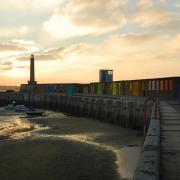
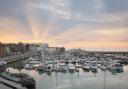
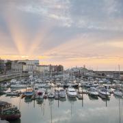
Just before you reach the main road ahead, turn right and here you will see the entrance to Whitstable Harbour up in front. Walk along the harbour as the path snakes through a thriving area of market stalls selling traditional seafood delicacies. When you see the RNLI lifeboat station in front of you, turn right, head towards the sea, and follow the pathway that leads along the coastline ahead of you (with rows of traditional sail boats lined up neatly to your right).
Continue straight on this stretch of path beside Whitstable’s pebbled beach for approx 750 metres, making your way towards the white weatherboard-clad Old Neptune pub up ahead (known as 'Neppy' to locals, and one of only a handful of pubs to be found on the beaches of Britain). Approx 150 metres before you reach the pub, keep a look-out on your left for an exciting slice of Whitstable’s maritime history brought to life. The last remaining Whitstable Oyster yawl, 'The Favourite' was one of 80 ships responsible for dredging the Whitstable coastline - at one point these were supplying London with half of its oysters.
Walk straight past the Old Neptune and continue along Marine Terrace, where on your left you will pass a row of houses painted in a variety of eye-catching shades, and a grouping of tennis courts. At the far end of these sports pitches turn left onto Wilks Way, a short stretch of road leading you on to Island Wall road.
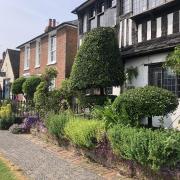
Turn left onto Island Wall and walk straight for just under 500 metres until you reach the main road, where you will see the Duke of Cumberland Hotel across the road in front of you. This particular stretch of the circuit will appeal particularly to those ramblers with a keen interest in houses, with a pretty selection of homes lining the full length of the street on either side.
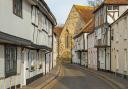
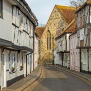
When you reach the Duke of Cumberland pub, cross the main road and head left, entering Harbour Street (the road that sits to the right hand side of the pub, with Whitstable Produce Store located at its entrance). Harbour Street is peppered with a wide range of inviting independent shops and eateries, which walkers will enjoy perusing as they walk its full length.

At the far end of this picture-perfect high street you will find a zebra crossing leading across the main road to the Whitstable Marine shop building. Sitting to the right of Whitstable Marine you have now arrived back at Whitstable Harbour, and upon entering, you should see the RNLI lifeboat station in front of you once again.
Turn right, heading back through the harbour before retracing your earlier steps from the entrance of East Quay towards the scenic slopes of Tankerton, where today’s route concludes back at Marine Parade.
Steps, stats & stiles
About: at just under 3 miles (4.6km) this circuit should take you just over one hour to complete if walking at a steady pace. Ramblers are encouraged, however, to build in some additional time in which to enjoy the sights of this popular seaside spot as you go. With no stiles or obstructions the route is predominantly pathed.
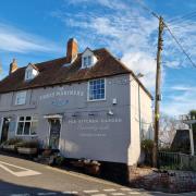
Refreshments: there’s certainly no shortage of great places to eat and drink in Whitstable. Tuck into the area’s local delicacies from any one of a number of venues (including Wheelers Oyster Bar and The Lobster Shack), indulge in a hot, vinegary portion of fish and chips (V.C Jones of Whitstable), or satisfy your coffee and cake cravings (The Kitchen, Whitstable).
Make a day of it: for plenty of inspiration of ways to extend your day in Whitstable, and nearby Canterbury and Herne Bay, visit https://www.canterbury.co.uk/.
Route followed: for this month’s walk we followed the Coastal Trail and Oyster Walk route, designed by Whitstable Maritime, opting to add some additional steps at the start and end in order to extend the route slightly. For more information, visit: https://whitstablemaritime.org.uk/oyster-walk/.