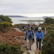
Edward Griffiths follows in the footsteps of Romans on this route between Hamworthy and Badbury Rings. Along the way he enjoys some fine views over the Stour plains towards Poole
Popular with commuting families due to its proximity to Poole, Corfe Mullen is surrounded by beautiful countryside. On this fine walk, we explore nearly two-straight miles of the Roman Road’s route between Hamworthy port and Badbury Rings, visit the site of an 19th-century lavender farm, explore a handful of heath and woodland nature reserves, and pause at a recreation ground with fantastic views over the Stour plains to Badbury Rings, Wimborne Minster and Poole.
Information
• Distance: 4¼ miles/6.75 km
• Time: 4 hours
• Exertion: Marginally strenuous. Some ascents but no stiles.
• Start: Hill View Car Park, Springdale Road, Corfe Mullen (Grid Ref: SY986958)
• Map: OS Landranger Sheet 195
• Public Transport: Morebus No. 3
• Dogs: On leads where instructed and on roads
• Refreshments: The Holme Bush in Wareham Road for ales and restaurant meals
The walk
1. Take the gravel path away from the road through bramble into woodland. At a crossing track, before the facing gate, turn left. Emerging into the lane at a footpath-post, continue to the T-junction. Turn left down past scattered houses, then meandering up with glimpses of Poole Harbour right. After the 30-sign into Corfe Lodge Road, pass Lavender Lodge right, the site of a former 19th century lavender farm. Some brick outbuildings still survive in a nearby garden. At the end T-junction, turn left up Roman Road. Reaching Gladelands Way T-junction, cross into the Tarmac footpath, rising under trees.
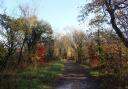
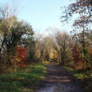
2. At the top, between the East Dorset and Poole boundaries, cross Springdale Road into the gravel path. Becoming a wider track, ascend past houses and under trees into the Tarmac drive. Pass left Caesar’s Way and right High Park Road. Over the top, descend to Roman Road with Albert Road left and Abbotsbury Road right. Perfectly straight, continue past rights and lefts, to Highfield Road/Lancaster Drive T-junction. Cross past the ‘bus shelter into the Tarmac drive, becoming gravel bridleway-path with Corfe Hills School playing field right. Continue under trees and descend through bracken with Corfe Heath right and getting steeper before reaching Higher Blandford Road. Go left/right into the unsigned drive down to some left houses. Then, rising under trees, go past the Corfe Hills Nature Reserve Rushcombe Bottom gate.
3. At the fork, keep straight on for ‘Bridleway1’, then instantly fork left up the lesser path, along the left fence at first. With houses over to the left, pass a metal barrier and keep to the path through trees, passing bridleway-arrows on a left gate. Past right Barrow Hill house, the track widens with right fields. At a crossing with a left footpath, continue down under trees until you meet Merley Park Road, signed back ‘B R Upton’. Go right/left into ‘Bridleway 6’ into Happy Bottom Nature Reserve. Keep following the path down, over the stream bridge and up, taking the left bridleway-arrowed fork, then up the stepped slope with a green bridleway-post.
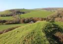
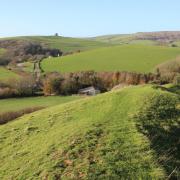
4. Rising and meandering through woods, join a lower track at another green bridleway-post. Continue past the Happy Bottom board and along the left garden wall into a clearing surrounded by houses. Turn left along the gravel road. Past 1904 East End Cottage left, reach the end of Pine Road, signed back ‘Public Footpath’. Cross Wimborne Road into footpath-signed Wayground Road, gravel again. Through the facing bollards, continue to Stour View Gardens T-junction. Go left/right into the bollarded path. Continue between fences, bending left at the facing gate’s three-way footpath-post. Into Corfe Mullen Recreation Ground, there are fabulous views over the Stour plains right. Continue along the right fence and hedge for about ½ mile into the far corner trees.
5. Continue into the Tarmac path down past footpath-arrows into Rectory Avenue. Turn right and go round left and right bends to Blandford Road T-junction. Turn right down to first left Sleight Lane. Along here, pass charming older brick cottages with fine views, then descend past houses and fields. At the T-junction, with white houses opposite, turn right then left into Haywards Lane. Walk up the road with fields and woods and into an estate. At Brook Lane T-junction, turn right. When the Tarmac ends past a de-restriction sign, take the left bridleway-track, still Brook Lane. Rising, levelling and descending right to three bollards, continue down to Blaney Way. Turn right then left into Hillside Road.
6. Stay on this road, passing lefts and rights, and ascending past Henbury View First School. Over two summits with glimpses of lovely views, continue up to the de-restriction sign and bridleway-arrow where the road narrows. Continue, with attractive houses left, along alternating Tarmac and gravel stretches before widening again. Reaching Wareham Road T-junction, turn left up the hill. Past the roundabout sign, cross right into Corfe Lodge Road footpath-track. Continue to the crossing with the car park to your left. Before returning, go right for 500 yards to Upton Heath viewpoint (marked with a dotted line on the map) for stunning views over Poole Harbour to the Purbecks.
Explore Happy Bottom Nature Reserve
Situated at the northern end of the Corfe Barrows Nature Park this Dorset Wildlife Trust reserve includes the stream valley that flows towards the River Stour to the north. Sections of the valley support wet woodland of sallow (grey willow) and birch but where the ground slopes away from the stream, on drier ground, there is oak, holly, rowan and alder buckthorn. Near the centre of the nature reserve are the remains of Cottage Farm which used to support a small dairy herd that grazed the adjoining meadows. The wet and dry grassland support a range of wildflowers in the spring and summer. More at dorsetwildlifetrust.org.uk.