SIMONE STANBROOK-BYRNE discovers the recently-designated Franklin Trail around Totnes

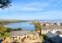
Totnes, sitting to the east of Dartmoor and at the top of the South Hams, is known for being a less-than-conventional place and is one of my favourite Devon towns.
So when the chairman of Totnes Ramblers contacted Devon Life to tell us about a newly-designated Trail that had been established as part of a legacy bequest from one of their members, Edward Franklin, it seemed like a great time to head down and check it out.
The Trail circumnavigates the town with several options to shorten the walk by cutting back into town centre. It is a well-signed walk of contrasts. If time and energy permit I suggest you also explore the wonderfully historic heart of Totnes - it is full of fascination.
Armed with a downloadable leaflet from the Ramblers website and accompanied by Bossington Bear, the walks mascot, and a husband, I set off one bright day in early spring...

Route:
1) The Seven Stars is a noticeable point from which to start the walk along The Plains, walking away from the busy junction with the Wills Monument to the right.
Development along the wharf prevented us from walking on the riverside path so we headed along the road to the Steam Packet Inn, about 300m from the start.
From here we turned right uphill on a narrow road, up which an arrowed Franklin Trail badge directed. This is Moat Hill.

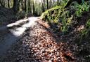
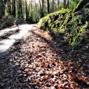
Climbing quickly, we soon went right into Maudlin Road, then left along the curiously-named Fishchowter's Lane. There's no name sign here but more arrows guided us. Earth, rather than surfaced road, was now under our boots and things began to feel more rural.
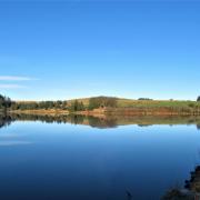
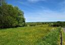
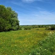
2) Views opened up as we climbed, the church towering above the Totnes roofscape. A stream babbled busily in the valley to the right across which we could see the old Toll House and an array of allotments.
The path climbed steadily, the early green hint of wild garlic promising a fragrant walk for those following later in the spring.
After about 600m of uphill we reached the T-junction where those disinclined to attempt the even-steeper hill could take a shortcut. Following the steep route, we went left - and it certainly was a puff. The ever-increasing views made it all worthwhile and took our minds off the exertion.

In about 500m we reached the next bridleway T-junction where a fingerpost points right along Bowden Lane. Another rural 500m brought us to a road, and turning right we were soon delivered into the sudden noise of the A381, a busy road with, thankfully, a pavement.
3) We turned right along the A381, soon passing the front of the Toll House we'd seen earlier. Further on we had a closer look at the allotments over the wall on the right, looking across the valley at the path we had just travelled.
Almost 600m along the main road we arrived at the pleasingly sunlit Cistern Street. One of the shortcuts can be taken here but we were aiming for the full circle so Harper's Hill was our next waypoint.
This steepish ascent is on the other side of the traffic-ridden A381 from Cistern Street - I suggest you go all the way down to cross at the traffic lights and then come back up again.

Near the bottom of Harper's Hill a pleasing, spring-fed water trough gushed refreshingly. Initially surfaced, this is a steep climb that passes Colwell Wood on the right and a few houses.
Inevitably, as on any walk that passes close to human habitation, we encountered a degree of detritus. Too much to stuff into a rucksack, all we could do was turn a blind eye and offer up a prayer to the god of grime that it might be collected.
Harper's Hill climbs breathily for a stout 700m before arriving at a surfaced lane near buildings, along which we went right. Another 200m brought us to Tristford Cross where we turned right.
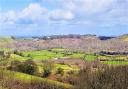
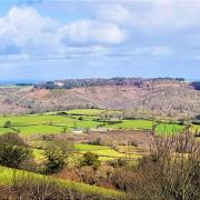
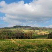
4) There now followed half a mile of fabulous views and easy lane walking. This is an elevated stretch with a thirst-quenching panorama towards Dartmoor. Listen for the toot of steam trains below on the South Devon Railway between Totnes and Buckfastleigh.

After half a mile a fingerpost directed us right, downhill on a byway known as Jackman's Lane, although nothing tells you this; bizarrely we followed a white van down here through the mud only to witness it reversing out again five minutes later.
Jackman's Lane is flanked by some rather splendid trees and in just over 600m a 'county road' track goes left, but we ignored this and continued down to Follaton Cross, crossing straight over the road here to join the lane to Dartington.
5) Within 300m the lane crosses the railway - a chance to wave should you so desire. We then continued up the lane for another 400m, ignoring Lower Copland Lane and taking the clearly-signed Copland Lane a little further on near some houses where we encountered nice cats.
Beyond the houses the track becomes unsurfaced and passes beneath a lovely oak. Keep going, looking out for the stand of eucalyptus trees on the right before you reach the T-junction of tracks; I have gathered eucalyptus pods from warmer climes to make a sumptuous bath soak - somehow English ones don't have the same effect.

At the T-junction we turned left downhill, still following a track. There were good gateway views to the right as we dropped and, later, a glimpse of the turrets of Totnes Castle.
Eventually, near houses, the way became fearfully muddy, so much so that we scrambled up onto the bank and made our way along up there out of the mire. Here I spotted dog's mercury growing, an indicator of ancient woodland; an exotic and disdainful cat watched us from some elevated decking as we slithered about.
6) Almost half a mile from the T-junction the track emerged into residential Copland Meadow, where we turned right to soon reached Barracks Hill, turning right again. At the junction we turned left, heading for the traffic lights at the Redworth Junction of the A381 and the A385 - a noisy spot.
We crossed over, bearing right towards Station Road then going left along it to the station and Signal Box Café, where we happily rested our boots and refuelled with free-range egg baps, beans on toast and mugs of tea as we watched the roofs of trains go by.

Refreshed, we crossed the zebra crossing at the station entrance and followed a narrow footpath between a grape-hyacinth adorned wall on one side and razor-wired fence on the other.
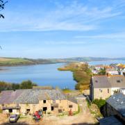
A tall chimney towered above. Soon the path left the industrial-feeling area and wended its way pleasingly beneath trees as is headed towards the weir.
7) We turned right over the second footbridge spanning the leat and headed over to investigate the mighty Archimedes' Screws of Totnes' hydropower scheme, busy generating from the force of the River Dart.
From here we followed the path with the river to our left, spotting a goosander flying above the river.

We soon joined the surfaced cycle path and passed the entrance to Totnes Riverside Station, home to the steam railway, then ducked under the railway bridge before continuing beside the river. Primroses, wood anemone and more wild garlic peeped through beneath the trees, one of which had a canine memorial attached to its trunk, with a couple of favourite toys belonging to a dear-departed companion.
Beyond the railway we stayed beside the Dart for another half a mile, before passing beneath a road bridge.
After this the Trail went right then quickly left again, still following the river to another road bridge visible ahead. Along here we had a treat: a beautiful mute swan building a nest in anticipation of spring.
At the bridge steps brought us up to the road and we found ourselves back at The Plains. The town itself, with its array of historic sites, restaurants and independent shops, was calling...
Next month we head for Killerton
Ordnance Survey maps are available from all good booksellers and outdoor stores or visit our online shop
Note: A leaflet covering this walk and options on short-cuts can be downloaded from: ramblers.org.uk/go-walking/group-finder/areas/devon/groups/totnes/franklin-totnes-trail
Use the leaflet in conjunction with this description so that you have all the options
Start point: The Plains, Totnes, TQ9 5DD. Grid ref: SX805603
Parking: Many options in Totnes, we used the facilities at Steamer Quay (TQ9 5AL)
Directions to start: Totnes is in South Devon, on the A381 and A385
Public transport: Well-served by buses and trains (see travelinesw.com)
Map: OS OL 20 South Devon 1:25 000
Terrain: Green lanes, footpaths, bridleways and roads. Muddy in places
Distance: 6¾ miles (10.9km) with options on sort-cuts described in downloadable leaflet (see note above)
Dog friendliness: Good, but take a lead for the roads. The Signal Box Café can't accommodate dogs but the coffee shop beneath it does
Exertion: Moderate with some strenuous climbs if the whole route is followed
Refreshments: Signal Box Café, Totnes Station (TQ9 5JR), phone 01803 867466. Many facilities in town if you explore further
Simone Stanbrook-Byrne and James Clancy have produced a selection of West Country guides including: Town Walks in Devon, Favourite Walks in Devon, Circular Walks in the South Hams, Circular Walks in East Devon, Circular Walks in Central Devon, Circular Walks in North Devon/Exmoor, A Dozen Dramatic Walks in Devon. culmvalleypublishing.co.uk / 01392 881513