
Enjoy wildflowers and sea views on this circular coastal city walk advises Hazel Sillver
Undercliff walk
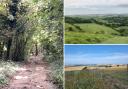
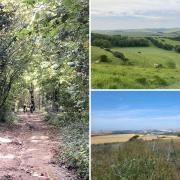
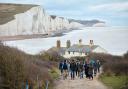
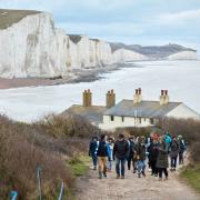
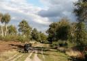
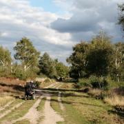
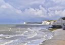
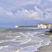
The Undercliff Walk runs for 4.5km (just under three miles) from Brighton Marina to Rottingdean and then Saltdean, providing Brightonians with a welcome relief from the city. The walkway is atop the sea wall, which was built in the 1930s to prevent the chalk cliffs from eroding; without it, the cliffs would erode at a rate of half a metre each year, putting the main A259 coast road above at risk. In July, the pretty path that runs along the cliff tops above blooms with wildflowers such as sea lavender, ragwort, field bindweed, red valerian, wild carrot, common thistle, common mallow and common vetch.
Safety warning
Despite the protection of the sea wall, the beautiful chalk cliffs do erode. For this reason, please stay away from the very edge of the cliff tops, do not climb over the clifftop fences and keep small dogs (who could run through the fence wires) on a lead.
Where to refuel
Ovingdean Gap Café is at the halfway stage on the Undercliff Walk. To find Busby and Wilds pub (busbyandwilds.co.uk, 01273 696135, BN2 1NF) or Marmalade café (cafemarmalade.co.uk, 01273 606138, BN2 5JJ), cross over the main road at the end of the Duke’s Mound Garden Walkway, walk along Lewes Crescent, through Sussex Square and head left along Eastern Road; the café is on the right or head left along Rock Street to reach the pub. Alternatively, the Yellowave Barefoot Café is at the start and end of the walk on Madeira Drive, just east of Duke’s Mound (yellowave.co.uk, 01273 672222, BN2 1EN).
Information
• Location: Brighton, East Sussex
• Distance: 4.4m (7km) – two hours to walk.
• Terrain: mostly flat, but the walk includes steps and slopes
• Where to park: At the bottom of Duke’s Mound, on Madeira Drive, Brighton
The walk
1) Walk up the steps at the bottom of Duke’s Mound road and head east along the wide pavement of the main coast road (Marine Parade). After ¼ mile, you will pass the iconic Regency buildings of Lewes Crescent and Sussex Square, and the private six-acre gardens they contain, known as the Kemp Town Enclosures.
2) At the end of the impressive Regency houses of Arundel Terrace, cross over the slip road and continue to walk along the south side of the main coast road, which now curves slightly. Soon, if you wish, you can leave the main footpath and cycle lane and walk along the narrow grassy path of the cliff tops. Follow this grassy path alongside the fence for ¾ mile.
3) Here cross over the wide path that leads downhill to the Marina, and continue on the grassy footpath along the cliff tops for another mile.
4) At the turquoise railings, aside from the Ovingdean roundabout, head down the steps to the beach. At the bottom, head west along the Undercliff Walk for one mile.
5) As you reach the Marina, ignore the path that heads right uphill and the path heading left along the marina wall; instead maintain direction straight ahead, following the Undercliff Walk past the boatyard and then the moored boats and apartments of the Marina.
6) After the fig tree, above the Asda car park, ignore the path that leads uphill right in stages and continue along the wide walkway above the car park. At the corner maintain direction, passing through the small tunnel and walking uphill.
7) At the top of the slope cross the cycle lane, walk up a few steps, turn left at the stone arch and head along the gravel walkway through Duke’s Mound Gardens. Halfway along you will pass the (locked) gate to the Kemp Town Enclosures, to which only residents have a key. This tunnel (which leads down from the gardens to the beach) is said to have been the inspiration for the rabbit hole in Alice in Wonderland – Lewis Carroll spent his summers in Sussex Square and is said to have loved the gardens.
8) At the end of the garden walkway, head upslope to a road junction. Here head left, walking downslope, along the pavement of Duke’s Mound road, back to the car.