A warm summer’s yomp featuring a little Cold War history, up and down Cheshire’s hillier territories
Standing on Croker Hill on a clear day, you can see Snowdonia in one direction and Manchester city centre in another.
Even on a greyer day, the panorama of the Cheshire Plain laid out before you tends to take your breath away. Jodrell Bank glints up at you from all this vastness like a penny on a pavement. But on this windswept hilltop, there is a rather less appealing pile of technology right there at your shoulder: the Sutton Common BT Tower.
The original incarnation of this tower, in the 1950s, was a monument to that fearful era of the Cold War, when nuclear war seemed a distinct possibility. The telephone cable system would be destroyed when the bomb went off, it was assumed, so a series of towers on high ground - the Backbone network - was planned. Microwave communications between them would keep the country functioning. Sutton Common's place in the chain would be to 'talk' to a tower at Heaton Park, just north of Manchester, and Pye Green in Staffordshire.
Thankfully, the bomb never did go off and the tower now serves the more mundane function of transmitting the signals of local radio stations.

By the time you reach that tower and Croker Hill, you've done all the hard work on this walk, climbing up steadily through Rossen Clough, negotiating what may be some rough and muddy sections. The return journey is easy on the legs and, with those splendid views, easy on the eye. Take your time to take it all in.
1. Parking around the start point of this walk, in Hollin Lane, is almost non-existent, so this is probably a walk to combine with a pub meal, thus justifying using the car park at the Ryles Arms, postcode SK11 0NN. Exiting the pub car park, turn right along Hollin Lane, taking great care as there is no pavement. Just after a row of houses on the left, and just opposite the entrance to Lowerhouse Farm on the right, take the track which peels away uphill to the left, and follow it up past Lower Kinderfields Farm. Keep to this bridleway for quite some time as it weaves through the valley.

2. The track climbs towards a sign for Civet Hills House. Before reaching this sign, take a gate on the left to a footpath down into a rough field. Go through a metal gate, passing a pond on your left and keep ahead on this path through several wooden gates. The path is indistinct, but just keep the stream on your left and follow the blue direction markers at each gate. After passing a farm on the left, go uphill towards a blue direction marker on a wooden post. Views of distant hills begin to open up now. Go through a metal gate, straight across a large open field on the bridleway. The next metal gate brings you alongside Higher Pethills Farm. On reaching the tarmac drive, head left down it, but before reaching the cattle grid, go right through a metal gate following the blue arrow.
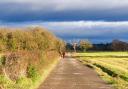
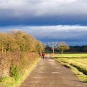
3. Go uphill and straight ahead, keeping the stream visible down to your left. At the next metal gate, don't go through; instead go right, following the footpath sign and head up the field ahead to a metal gate and stile. Cross the next field and two further stiles bring you onto the road. Go right for about 150 metres then bear right following the Gritstone Trail sign towards the telecom mast on top of Croker Hill. Through several gates, the path eventually emerges next to a farmhouse, to the left of the mast. Turn right onto the tarmac path and you soon find yourself enjoying some of the most panoramic views in Cheshire.

4. Keep ahead and you are now on a path running along the ridge for well over a mile. Don't be tempted by any paths veering off downhill, but keep ahead on the higher ground, skirting to the left of a little protuberance called the Hill of Rossenclowes, and following the Gritstone Trail. After passing a quarry on your left, you enter a large open field with a long row of trees to your right.
5. At the bottom of this field, bear right through a double kissing gate, following the Gritstone Trail. The path weaves down to pass beside a farm, with a steep wooded valley to the right, and soon after emerges on Hollin Lane. Turn right and retrace your steps back to the Ryles Arms. u

COMPASS POINTS
Area of Walk: Sutton, Macclesfield
Distance: 4 miles
Time to allow: 2½ hours
Map: OS Explorer 268
Refreshments: The Ryles Arms, Hollin Lane, Higher Sutton SK11 0NN