This is an outstanding coastal walk with snippets of history, as Simone Stanbrooke-Bryne discovers Photography by James Clancy

An outstanding blend of beautiful coastline and multi-layered history are key ingredients of this walk in South Devon. Peaceful now, save for the cry of seabirds, this area was a busy place during the Second World War when Brownstone Battery was built to protect the Dart Estuary against attack.

The coast path passes through its extensive remains, part of which now houses a modern-day station of the National Coastwatch Institute. Visitors are welcome to pop in for a chat with the volunteers here. Also, keep an eye open for the day mark tower, an 80 feet high listed building constructed in 1864 as a navigational aid.
Similar in purpose to a lighthouse, it has no light for night use – hence the name ‘day mark’. Take your binoculars: there’s a good chance of seeing seals basking on the rocks around the Mew Stone, look out for peregrines, the fastest creature on earth, and listen for the chink of stonechats and the piping whistle of oystercatchers.
Directions:
1From the car park turn right along the lane for about 150m until you find a three-way fingerpost. Take the footpath going right signed as a link to the coast path. This follows the edge of the field, a farmhouse on your left, and emerges through a kissing gate on to a short path which joins a track. Follow the track away from the farm.
Keep ahead as you enter a field, still heading for the coast path – a lovely stretch of walking. At the end of this first field you enter a second, continue with the boundary to your right. At the bottom of the field a two-way fingerpost directs you left still in the same field, continuing downhill with the boundary still to your right. You reach a stile with lovely sea views, the mighty Mew Stone is to your right along the coast.
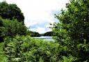
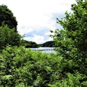
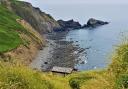
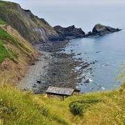
Continue beyond the stile to meet the coast path. Your way lies right towards Froward Point but first we recommend that you go left for a short way to admire the view into Pudcombe Cove from a convenient bench, and for a glimpse of the majestic trees adorning the Coleton Fishacre Estate, just along the cliffs.
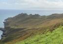
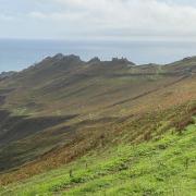
2Once you’ve had enough follow the coast path south west (sea to your left) for about one and a half miles towards Froward Point, enjoying the scenery, the birds and the seals. The lower rocks around the Mew Stone are often the favoured basking spot of the local seal colony; you may be lucky enough to spot the white one who hangs out with the rest.
Keep following the acorn-waymarked coast path beyond the Mew Stone and when the path forks keep left. As you round the headland you’ll have views of Slapton Sands across the bay and Start Point away in the distance. Closer to hand you’ll see the searchlight housings of Brownstone Battery before the coast path brings you right in amongst them, a welcome shelter if it’s raining.
From the enclosed searchlight hut you have a good view of Dartmouth Castle. This, together with Kingswear Castle (out of sight on this side of the estuary), was built after attacks on Dartmouth during the Hundred Years War with France (14th-15th centuries). A great chain was installed across the estuary which could be positioned at night to prevent the passage of ships. Dartmouth Castle remained in active service until the Second World War.
Climb the steep steps to the gun platform, from which you can look down on the roofs of the searchlight huts, then beyond the platform walk up the line of the miniature railway which brought ammunition down to the guns. A nearby information board tells you all about it.
3The tracks lead you to the ammunition store and the path continues up beside it, away from the sea, climbing more steps and passing other battery buildings until you arrive at the National Coastwatch Institution’s Froward Point Watch Station. If volunteers are on duty they welcome visitors and will tell you about their work. One hot summer’s day they very kindly refilled our water bottles!
Look inland from the NCI station and you will see the top of the day mark tower and, just across the grass, a four-way fingerpost by an information board. From the fingerpost take the coast path to Kingswear, two miles away. This path leads away from Froward Point, below the parking area and beside another battery building to head under trees. This is a pretty, undulating way along which you’ll find another well-placed bench overlooking the coves and coast below.
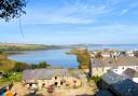
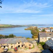
A gate leads you out of the National Trust land of Higher Brownstone. Keep going, passing beneath superb trees and enjoying the pine needle-softened path beneath them. Another viewpoint (and first class picnic spot) affords a glimpse of Kingswear Castle on this side of the estuary beyond Mill Bay Cove. Across the water, above Dartmouth Castle, you can see a water tower at Jawbones.
4Keep following the coast path until it descends steps to a two-way fingerpost by an unmissable turret in the grounds of a private house. Turn right along their drive and in about 20m, just before a cattle grid, go left to continue on the signed coast path. Pass through a gate and take a deep breath as a very uppish bit is ahead of you.
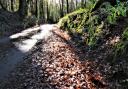
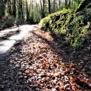
Steps ascend through Warren Woods to eventually cross a welcomingly flat drive. Beyond this carry on up more steps until you reach another crossing drive beside a stone plinth bearing a plaque dedicated to the memory of Lt. Col. Herbert Jones, who preferred to be known as ‘H’. He was killed in the Falklands and in 1984 this path through the woods was dedicated to his memory and opened to the public.
5A nearby three-way fingerpost directs you right towards Brownstone, leaving the coast path to continue without you. Head along the surfaced track, refreshingly flat after the last bit and from which you still have coastal views. At a fork, in about 200m, keep right towards Brownstone, passing the elegant edifice of The Grange.
Within another 200m, near Home Farm, a two-way fingerpost near a decorative telephone box directs you right, following a garden fence to your left. This stony path can be extremely wet as it climbs for nearly 400m to Crocker’s Cottage.
Continue along the drive beyond to arrive at Higher Brownstone Farmhouse where you’ll see a three-way fingerpost beside the wall on the right. Keep ahead towards Coleton Fishacre, glancing right for another view of the day mark tower, keeping its eye on you across the fields. Follow the lane all the way back to your car park.