Enjoy a lovely stroll from the village of Steeple Bumpstead, through Moyn’s Park to the village of Birdbrook and back again | Words and photos: Laurie Page Public Rights of Way Team at Essex County Council

1) From the village hall, return to the road and turn right along the pavement. After passing the cemetery, take the footpath on the left, going along the edge of a very large field.
At the next footpath junction do not cross the bridge but go right alongside a ditch. Continue on across a crop field and when you reach the end of the field by the hedge, turn left and then right over a footbridge and immediately left over another bridge.

2) Go along the field edge for a short distance and then turn right at the next path junction, through a kissing gate and across a meadow to the next kissing gate.
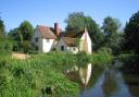
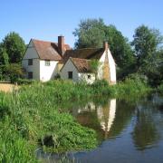
The path continues through trees and into another field. At the concrete track, turn left and follow the track passing the magnificent Moyn’s Hall. At the track junction keep left and follow the track all the way to the gates by the road, where you turn left.

3) Go along the road into the village of Birdbrook. Pass The Plough pub, then go to the left of the church and through the churchyard. In the corner you emerge into a field, going diagonally across it and along the boundary of the next field. Where the hedge ends, turn right along an unmarked footpath, so that the hedge is to your right.
Go gently downhill to the corner where you swing left and at the end of the hedge, go right alongside a wood. Bear left at the corner of the wood and halfway along the wood, at the footpath way-marker, turn right, keeping the hedge to your left and proceed down to the road.

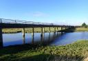
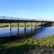
4) Turn left along the road (B1057). Use the verge but watch out for traffic, especially at the sections of the road where the verge disappears. At Broad Green, after a row of houses, turn right up a little lane, immediately crossing the river.
After the first house look out for an unmarked footpath on the left, going through a wood and out into a field alongside the stream. Go over a footbridge. When you reach the next footpath junction by the bridge, go right across a crop field, heading for the cottages. You come to a lane where you turn left.

5) At the next road junction, advance straight on (on the Haverhill Road) along the pavement. Go straight on again at the next road junction into Steeple Bumpstead village. Pass the petrol garage.
Then turn left onto a footpath going over the river bridge and at the road turn left again passing St Mary’s Church, the pottery and two pubs. At the road junction turn right into the Finchingfield Road. The village hall is a little way along on the right.
Distance: 4.6 miles (7.4 km)
Starting point: The Village Hall on Finchingfield Road (B1057). Sat Nav CB9 7EB.
How to get there: Steeple Bumpstead is about 3 miles south of Haverhill, where the B1057 and the B1054 intersect.
Map: OS Explorer 210 Newmarket & Haverhill
Refreshments: There are two pubs in Steeple Bumpstead, The Fox & Hounds and The Red Lion. You also pass The Plough about halfway round en route in Birdbrook.
Places of interest nearby: Steeple Bumpstead lies close to the Essex border with Suffolk. Haverhill is a busy Suffolk town with a popular Arts Centre, a leisure centre and recreation ground, as well as many shops. Seven miles north east of Steeple Bumpstead is Linton Zoo and to the east is the historic Essex town of Saffron Walden.
_____________