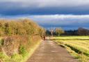
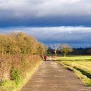
Keith Carter takes his family for a stroll through the countryside around Coddington

Every so often I consider whether the walks I describe are suitable for families with children or ‘young persons’ as they prefer to be known. I sometimes wonder if it is politically incorrect to use the term children. What better way than to recruit my son and his boys aged 11 and 13 to join me and use them as guinea pigs. I say that without intending any disrespect to the small rodents of that species.
It was with this in mind that we made a rendezvous in Coddington one morning following a spell of wet weather. Coddington is not really a village now, merely a few scattered farmsteads, the church and a small quaint building called the Parish Rooms – oh, and a red telephone box, probably a listed building. Now that everyone uses mobile phones, telephone boxes are something of an anachronism and will soon be collected like pillar boxes, curious relics of an earlier age.
There is just enough room for two cars to park without blocking the gateway although I can’t see any objection to roadside parking here. Slightly surprised to have actually found Coddington, we set off in high spirits, the church clock just at half past ten.
Coddington is mentioned in the Domesday Book, dating from a time when it was of greater importance than it is today, being a staging post on the road to Wroxeter. The present day church dates from the 19th century but like most country churches these days was firmly locked, preventing me from looking for points of interest to pass on to you, dear readers.

Coddington takes its name from a former yeoman big in these parts called Cot or Cotta, or so my Dictionary of English Place Names tells me, falling back on the usual explanation when there is no river to name it after. Cotta is not a name that has kept its popularity in our area.
1. Passing the church on your left, stay on the road as far as the substantial buildings of Crooke Farm just beyond which take a stile in the hedge on the left and cut across to a second one next to a large silo tank. The footpath follows a line of trees on a trampled earth track, passes a reed-fringed pond and enters a field, at the far end of which is a footbridge over a brook. Cross this and keep forward heading towards a line of trees sheltering a group of houses. Follow the fence round to the right and meet a lane at a stile where we turn left, following the lane past the houses.
2. At a gate we cross a stile and continue along a left-hand boundary then enter a farm track which becomes enclosed between hedges. The footpath goes between two stone gateposts to meet the road at Aldersey Green where we turn left. On the right you will see what looks like the lych-gate to a church but is in fact a war memorial housing the village pump. Our two young walkers failed to coax any water from it in spite of vigorous pumping which called for a refreshment break, one of several throughout our walk.

The road takes a sharp right turn but we keep forward through a gate on a bridleway which meant that the next few gates had the lever that allows riders to open the gate without dismounting. Actually the gates are not the problem, the paths being neglected and overgrown.
3. We cross two footbridges, one over Mere Brook and the other Stonyford Brook, and we maintain the same direction, north, until the path takes a right turn at which point we take a stile in front of us then another on the left into a field of maize. A broad path has been cut through it heading for a large imposing house, Calverley Hall, which was smothered in scaffolding when we were there, undergoing renovation. A path has been indicated by a line of tape to take walkers round the building work, taking us round to the back of the house and joining a way-marked trail known as Bishop Bennet Way, a 34 mile route intended for horse-riders, linking Beeston Castle with Wirswall on the border with Shropshire. It’s well sign-posted and several of my rambles have used sections of it.
The boys seemed to be keeping up well with the aid of regular snacks to boost their energy levels and charge their batteries. The younger one took over the map and navigated for the rest of the walk quite effectively. I was reminded of one of the place names from the book The Meaning of Liff, a humorous catalogue of possible definitions. A ‘Wendover’ is that point on a family walk when the youngest won’t go any further. I’m glad to say we had not reached it yet.
4. Once past Calverley Hall the path proceeds through fields, keeping to the hedge line, branching right at a divide where a signpost says the left fork is private and the right leads to Lea. We cross another footbridge then join a neglected path interspersed with newly installed galvanised gates with levers for horse riders reminding us this is still a bridleway.
Ahead across a field we can see a farm with extensive silos and we head for this, bearing left on reaching the buildings and joining a lane at the gateway to the farm, Lea Mosses. Turn left and stay on the road, crossing a stream by a bridge and continuing past a property called The Ponderosa which will raise a smile from fans of the sixties TV western Bonanza.
5. The lane remains metalled to a T junction where we turn left then in a hundred yards strike away to the right across fields of crops. The brown signs for Bishop Bennet Way are still keeping us on track. At the far side of the second field a gap in the hedge brings us to a farm track where we turn right. Continue on this same path between hedges until we emerge at Old Beachin Farm where they seem to be breeding peacocks then Middle Beachin Farm where the track becomes surfaced bringing us to a junction with the road. Turn left, staying on the road back to Coddington Parish Rooms where we parked.
My guinea pigs were still in good heart but glad to have come to the end of the walk which at nearly 12km was a tad too far for them. I can imagine some children reaching their Wendover moment at about the 8km mark. Young people in general don’t ‘get’ walking. They can’t see the point. The truth is that there isn’t really a point, as such, just the sense of achievement at the end and the satisfaction of having completed mileage under your own steam, including climbing stiles, crossing footbridges, negotiating rough ground and overgrown pathways past farms and fields with only the open air and the ground beneath your feet for support. Next time, not quite so far and how about a nice teashop part way round, with a slice of Rocky Road to help you on your way? Sounds good to me.
Compass points
Area of walk: Coddington, Cheshire
Distance: 7½ miles
Time to allow: 4 hours
Map: OS Explorer 257 Crewe and Nantwich
Refreshments: None
Accessibility: Not suitable for wheelchair or pushchair users.