Keith Carter leads a walk through Lancashire's industrial heritage in the hills near Bolton
This month’s walk is from Smithills Hall, a fine restored black and white half-timbered manor house now in the care of Bolton Council and open to the public as a museum. It has been through numerous changes over the centuries both in its use and appearance so it is difficult to place it in any one era.
The first written references relating to Smithills record its purchase by one William Radcliffe in 1335 and from 1801 the hall was owned by the Ainsworth family, a successful dynasty of Bolton bleachers whose works occupied the land in the vicinity of the great chimney which is all that remains standing. We pass it later in the walk. The hall was extensively modernised and rebuilt through the 19th century but after World War One it became impossible to maintain the estate and it was acquired by Bolton.
You can be excused if you give a visit to the hall a miss although one curiosity that might raise a smile is the impression of a footprint on the floor to the entrance to the withdrawing room, said to be that of a Bolton farmer, George Marsh, who at a time when Catholicism held sway was persecuted for his Protestant views and eventually executed. Exactly why he came to stamp his foot is not made clear but he was obviously quite upset about something.
As you approach the hall the access road divides and by going right you can find some parking opposite the Coach House which now houses a restaurant, not, please note, a caf� or pub so don’t run away with the idea that you can get a coffee or a pint later unless you’re eating.
Having parked, return to where the drive divides and take the left fork which goes behind the Coach House. On the left you see a gate and this is our route heading towards a line of mature trees. Having entered the wood, cross the stream and before a gateway into a walled enclosure turn left and on a rising path follow the course of the stream until you see a gate immediately ahead. Go through this gate and make for a solitary house which brings you to a lane.
Here a sign indicates the right onto a ‘restricted by-way’ and we take this to enter Horrocks Wood by a gate. Ford a stream and bear right through an area that seems to have been reclaimed and landscaped for public use with some judicious tree-planting. The footpath reaches a group of barns and at a gate we turn down left to enter an area of residential property.
Once among the houses a tarmac lane descends and where it divides take the smaller, left hand fork and look for a footpath sign on the left where a concealed path leads away from the houses and continues along the top of a series of disused quarries known as Horrocks Fold Quarries now used only for leisure activities including rock-climbing and pistol shooting – not at the same time I hope.
Looking down from the rim you can see some curious columns left behind once the quarrying became uneconomic. Similar pillars in Cornwall are said to have been left for the anchorage points for cable hoists. The path reaches Scout Road and we go left to walk along the verge, in a short while passing a creamery selling ices followed by a road-side parking area where a good view can be seen over the surrounding countryside.
Don’t take the first turning on the left, Smithills Dean Road, unless you want to cut short the walk and return to Smithills but take the next on the left when you see a sign pointing left to Barrow Bridge just opposite a former school now converted into a house.
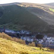
Descend this quiet lane to the village of Barrow Bridge which is strung out along a stream, Dean Brook where many of the houses to the left of the road are accessed over small footbridges. The village was built to house the mill workers built around 1820 by Thomas Bazley and Robert Gardner whose philanthropic principles inspired them to create a village on a self-help model rather in the manner of Robert Owen at New Lanark around about the same time.
Benjamin Disraeli is known to have visited Barrow Bridge in 1840 and incorporated it in his famous book Coningsby under the name of Millbank. Remind me to read it sometime. At the end of the village we pass the bus turning circle and public convenience and continue on the road with Moss Bank Park on the right.
Throughout this walk we have been within sight of a chimney and indeed we soon pass right by it, all that remains of Ainsworth’s Bleach Works, left standing when the buildings were demolished. It was once worked on by the late, great Fred Dibnah as a small plaque affirms. I imagine even he could not have dropped it without causing major disruption and damage so it stands as a memorial, or at least a reminder, of the industrial past.
At the chimney, turn left down Smithills Croft Road and as the lane bends to the right look for a footpath on the corner on the left. Take this, climbing a bank and it becomes enclosed as it passes behind houses then crosses a road just to the right of a primary school, continues for a short distance and emerges directly opposite the entrance to the hall. Keep ahead and take the right fork if you want to visit the museum or if not, the coach house is straight ahead.
This area has the past firmly stamped upon it if you know where to look although most of the traces of former industry have gone. That massive chimney remains and long may it do so as a reminder of a time when it was the centre of a hive of industry.
We forget how lucky we are.
Compass points
Area of walk: Smithills near Horwich.
Distance: 5.5 miles
Time to allow: Three hours
Map: OS Explorer 287 West Pennine Moors
Refreshments: Restaurant at Smithills Hall.
Useful web site: www.bolton.org.uk/barrowbridge
Disabled/wheelchair accessible: No


