Explore river valleys, woodlands and an ancient settlement on this lovely walk from Chawleigh, as SIMONE STANBROOK-BYRNE reveals Photography by Jim Clancy

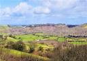
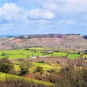
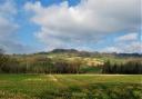
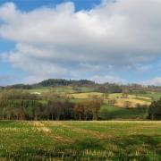
Although renowned for its coasts and moors, Devon offers many appealing woodland and farmland routes such as this; an atmospheric walk for a crisp, bright winter’s morning, accompanied by the music of small streams and the sun-spangled Little Dart River. The pre-Roman Burridge Settlement, redolent of lives long-gone, makes a thought-provoking addition to the walk.

1. Start outside the Earl of Portsmouth pub, a former coaching inn, and follow the lane downhill (signed for Cheldon and Gidley Arms). You soon pass Leaches House on the right, with the crest of the Earl of Portsmouth on its porch, and beyond this a small crossroads. Continue ahead for 1km on the lane out of the village, after which you cross the Little Dart River at Stonemill Bridge. A short way beyond this, at Stonemill Cross, turn right towards Cheldon.
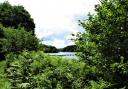
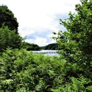
Continue for 350m to cross another small bridge. Ignore a left turn for Cheldon and keep ahead towards Lapford. You quickly reach Leigh Bridge and beyond this there is a public footpath signed left off the lane beside the river. Take this. The main body of the river is to your right now with a stream to the left.
2. The path broadens to enter a field, keep ahead with the meandering river over to the right. At the end of the field pass through a gate and continue under trees, river still to the right. Emerge into another field and continue, following the line of the left boundary. You pass a stand of trees to your right, keep going in the same direction beyond them, climbing slightly to pass through a tree-topped boundary less than 200m further on.
Beyond this boundary the path veers slightly right. It can be quite wet and you may need to hop across a babbling spring as you approach a stand of oak trees. The path continues beyond them, passing a few more solitary trees, to find a yellow-arrowed stile at the end of the field. At the stile the river is about 30m to your right. Beyond the stile follow the trodden path, there is a house up to your left and the path brings you out to a lane. Turn right.
3. Follow the lane as is it ascends to cross Cheldon Bridge; after rain there may be a slim, graceful waterfall to the left, cascading to the river below. Keep going up, passing West Burridge on your left and continuing for about 200m to where you find footpaths on both sides of the lane.
Your way lies to the right but first go left on the path signed for Burridge Ancient Settlement, a diversion of less than 200m (3a). The track rises to pass through a gate bringing you into the area of the settlement. Now the peaceful haunt of grazing sheep, this site was once abuzz with activity, the track beside it being a small segment of the network of trading routes that crisscrossed England. The settlement’s surrounding banks and ditch protected its people as they went about their lives. Ponder its history then return down to the lane and take the footpath opposite, crossing the field in the direction shown by the fingerpost to meet the outside corner of woodland 150m away.
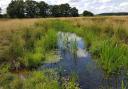
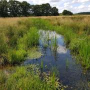
Here you find a yellow-arrowed gate. Pass through and follow the track beyond, going downhill under the trees, passing an arrowed post on the way and keeping an ear open for woodpeckers, jays and buzzards. Just over 150m from entering the woodland the path descends to cross a confluence of streams. A yellow-arrowed post points you right, across the stream, to another post less than 50m away which directs you left. Pick your way through this aqueous chicane, don’t sit down in the water and be glad you’ve got wellies on (we did tell you!).
4. Beyond the water follow the clear track as directed by the arrow, stream now to your left and rising ground to your right. After almost 500m you reach the lane at East Leigh, where you’ll be unlucky not to encounter a mighty collection of moggies. Go left along it for less than 150m and as the lane bends left take the track to the right.
In 50m the track bends right, leave it here, passing through a farm gate ahead into a field. Walk across the field in the direction of the arrow to a gate at the far side; you will spot the ivy-clad ruins of an old cottage over to your left and possibly a hovering kestrel hereabouts. Go straight across the next field, enjoying the views around you, to a yellow-arrowed footpath gate in the far boundary; this is set slightly low down so you won’t see it until you’re almost there.
From this gate cross the small field to another gate 100m away in the opposite boundary; then follow the direction of the arrow across the next field, past a solitary tree, to the outside corner of a tree-lined boundary where you find an arrowed gate.
5. Go through the gate and follow the trodden path, which vaguely follows the right-hand boundary of this small field. The path bears right to an arrowed post pointing you out of the field along a track. This leads to a gate onto a lane, turn left along it and within a few metres go right off the lane on a concrete drive between The Granary and Mildonsleigh (which spells its name differently to the OS map!). The concrete ends, keep going on the track until it stops at a gate with an attractively-framed view towards the church tower in Chawleigh.
6. Beyond the gate head across the field as shown by the fingerpost, following the same line as the track you’ve just left and aiming slightly left of the church tower. This brings you to the bottom boundary of the field where a post with a yellow arrow guides you past a lovely big oak with its own arrow on the trunk.
Go through the gate behind the tree and follow the direction of the arrow down a steep path – if the trees are without leaves you will still see the church tower ahead. Descend to an arrowed post pointing right to another post directing you left to cross a stream. Beyond the stream negotiate the stile and walk ahead up the hillside beyond. The path climbs and bears right to enter a field. Go through the field with the hedge on your left and good views to the right.
This left boundary brings you to a fencepost with an arrow directing you along a muddy track out of the field. Once through the gate follow the drive past several cottages, passing Leaches Farm on the left and emerging at the lane. Turn left to retrace your steps the short distance back to the village centre.
This walk has been taken from Circular Walks in North Devon one of a selection of walking guides by Simone Stanbrook-Byrne and James Clancy. Other titles include: Circular Walks in East Devon, Circular Walks in Central Devon, Town Walks in Devon, Favourite Walks in Devon (edited collection), A Dozen Dramatic Walks in Devon culmvalleypublishing.co.uk/01884 849085.