
Celebrate the 50th anniversary of the South West Coast Path Association with this challenging but rewarding section from St Agnes to Chapel Porth
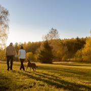
Cornwall is indisputably beautiful, and nowhere more so than its coastline. Where else can you combine heather-studded moorland and the smell of gorse drifting on the breeze with cerulean waters to your right (next stop, USA)?
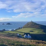
The stretch from St Agnes towards Portreath is one of the most iconic - an overused word if ever there was one, but perfectly justified here. The majestic engine house of Wheal Coates, perched perilously on the cliff edge with gravity-defying determination, is the stuff of picture postcards.
It’s also physical proof that while these shores may resound today with gentle birdsong and families having fun, once upon a time this was a dirty, noisy, industrial landscape that earned a crust for many a miner. This is tin and copper heartland, part of Unesco’s Cornish Mining World Heritage Site.
Drop a stone down a (safely covered) mine shaft at Wheal Coates and listen for the tell-tale splash when it finally hits the bottom; now imagine yourself working so far underground, your dirty hands wrapped around a pasty crimp at crib-time. While we romanticise the image now, we shouldn’t forget it was hard and dangerous work.
And so, to the walk, which isn’t dangerous but is certainly arduous in parts. (It can easily be shortened or lengthened, depending on your ability or keenness, by choosing a car park along Beacon Drive as your starting point, or diverting over St Agnes Beacon on the way back).
My family is especially fond of this stretch of coastline as my partner’s ancestors hail from here, and can be found in the churchyard, the fascinating little museum and, of course, alive and well in the village.
May is an exciting time in St Agnes. Bolster Day is held annually on the Sunday before the early May Bank Holiday. As legend would have it, the child-eating giant Bolster was challenged by St Agnes to fill a hole with his blood in exchange for her love. Little did he know the hole was bottomless; his blood flowed into the sea and he died, ridding the community of his wickedness. Agnes’ success is celebrated by way of a giant puppet procession.
And you can walk this route in good company as part of the South West Coast Path Association’s Trailblazer walk, which covers the whole 630 miles of this National Trail in celebration of its 50th anniversary. The northern leg starts from Minehead on May 12, the southern leg on May 27 from South Haven Point in Dorset; they meet at the Royal William Yard on June 15.
The walk enters Cornwall at Morwenstow on May 21, and the section from Trevaunance Cove to Portreath takes up the afternoon of Monday, May 29 (the Spring Bank Holiday). Booking essential: visit southwestcoastpath.org.uk

THE WALK
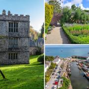
1. Park at Trevaunance Cove (we chose the main council-operated car park). Exit via the main road and turn left, heading down towards the cove, passing the Driftwood Spars Inn. Pause to read the fascinating history of this 17th-century building, which was built using ships’ timbers and boasts a wreckers’ tunnel behind the bar fireplace.
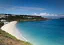
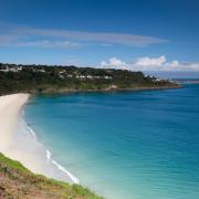
2. At the wooden fingerpost indicating the South West Coast Path, turn left along a tarmacked road which soon gives way to a coastal path and climbs. Pause to admire Trevaunance Cove behind you – on the day we walked, the weather was good and so was the surf, meaning the beach was busy. Look down and you’ll see stone with a distinctly manmade shape – the remains of the cove’s harbour, from which ships took copper to be smelted in Swansea and returned with Welsh coal, until its demise in 1917.
3. You’ll continue with the sea to your right, around Newdowns and St Agnes Heads, until you reach Chapel Porth – that's three miles. Looking back, you’ll enjoy far-reaching views towards Trevose Head near Padstow, easily distinguishable by its white lighthouse; in the other direction, a stunning panorama with Godrevy and St Ives just visible in the distance. The two rocks out at sea – one large, one small – have several names: Bawden Rocks (from the Cornish Meyn Bodyn), Cow and Calf or Man and his man; local legend claims that the rocks were thrown out to sea by the giant Bolster. He did local bird life a favour, at least; various species nest here, including puffins.
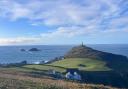
4. Pause a while at Wheal Coates – it's the perfect opportunity to explore Cornwall’s industrial heritage. The building most commonly seen is officially known as Towanroath Pumping Engine House; dating back to 1872, it was used to pump water from the adjacent 600ft Towanroath shaft.

5. Descend to Chapel Porth. Here, the beach is vast at low tide, bijou at high. There’s a National Trust car park, and a truly excellent café (outdoor seating only) selling a range of croque-style sandwiches and ‘hedgehog’ ice creams: vanilla topped with clotted cream and rolled in roasted nuts. Traditionally, the World Belly Board Championships took place here in September.
6. With your back to the sea, aim for the far right-hand corner of the car park, where you’ll find a little bridge. Cross the stream and turn left, following the South West Coast Path until it veers right and uphill. You’ll continue straight on (signposted with a black arrow), with the stream to your left, up Chapel Coombe.
7. The path enters a woodland. At a post, follow the yellow arrow left over two small bridges, then turn right down a track, keeping the stream on your right. At the next post, follow the yellow arrow right; the stream will be on your left again. The woodland here is charming, dotted with wildflowers (snowdrops and crocuses when we were walking).
8. Look out for a tree stump acting as a stepping stone on your left. Turn left and cross the stream here. The path narrows and passes between two wooden gates, continuing through woodland and eventually coming out at Two Meadows Nursery. The track bears left and meets a lane; turn left here, with Willow Cottage on your left.
9. At the T-junction, turn right and at the Give Way sign, turn left into Beacon Drive. We followed this all the way back to St Agnes; it skirts around the hill known as the Beacon, named after the practice of lighting a chain of fires that linked one end of Cornwall to the other, to mark special events. At 630ft, it’s the highest point for miles around, and is dotted with archaeological features. If you have the time and the energy, it’s worth a diversion from the tarmac; there are plenty of access points.
10. Entering St Agnes, you reach Rocky Lane on your left. Turn left down here. Follow the lane all the way down; at the bottom, you’ll see the council car park on your right.

COMPASS POINTS
Start/finish: Council car park, Trevaunance Cove, near St Agnes
Map: OS Explorer 104, Redruth & St Agnes
Distance: 6 miles
Time: 4 hours
Terrain: Coast path, rocky with inclines; woodland paths, muddy in wet weather; tarmac.
Refreshments: Chapel Porth Beach Café (01872 552487); Wheal Coates Tea Room on Beacon Drive (01872 552696); choice of cafes/pubs/restaurants at Trevaunance Cove.