Visitors to the Lake District have long tried to tackle on of the many 'Wainwrights', one of over 200 Lake District fells described in Alfred Wainwright's A Pictorial Guide to the Lakeland Fells. Now walkers to the Peak District can set themselves a walking challenge for the summits of the Peak District in the form of the ‘Ethels’
The South Yorkshire and Derbyshire branch of CPRE, the countryside charity (Campaign to Protect Rural England) have compiled a list of 95 of the Peak District hilltops over 400m above sea level that are compiled in a free app. The Ethels are named after environmentalist Ethel Haythornthwaite, who founded the organisation in 1924.
The 'Ethel Ready' app maps all 95 Ethels, and lists them by name with their height and grid reference and it helps you keep a tally of the ones you have undertaken.
We have looked through our extensive archive of walks to find six Ethels that you should visit. Some of these routes will take you to the summit, while others will require a short detour from the route, we recommend that you consult an up to date OS Map to plan your route.

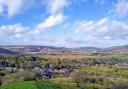
Eccles Pike
Summit height - 370m
The gritstone Peak, just over 1,000 feet above sea level, affords great views of Manchester, Kinder Scout, Chinley Churn and Cracken Edge on clear days. There’s a memorial to George Highley Sugden, first chairman of the Peak District National Trust, owners of this viewpoint.
Click here to view the details of the Eccles Pike walk

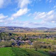
Lantern Pike
Summit height - 373m
Lantern Pike was given to the National Trust in 1946 and is thought to be named after being used long ago for a beacon. Follow the Sett Valley Trail and enjoy 360-degree views from a circular topography viewfinder at the summit.
Click here to view the details of the Lantern PIke

Minninglow
Summit height - 372m
The summit of Minninglow may be one of the smaller 'Ethels' in terms of height, but it is certainly one of the more remarkable. The hilltop summit has an iconic cluster of mature beech trees surrounded by an arboreal halo.
Click here to view details of the Minninglow walk

Croker Hill
Summit height - 402m
A walk in Cheshire just outside the boundary of the western edge of the national park. Standing on Croker Hill on a clear day, you can see Snowdonia in one direction and Manchester city centre in another.
Click here to view the details of the Croker Hill walk

Sir William Hill
Summit height - 429m
From Eyam Parish Church you head to Eyam Moor and the trig point of Sir William Hill, taking in many of the Peak District’s much-loved landmarks: the Kinder Massif, The Great Ridge, the popular edges that run along the Eastern Moors with a glimpse of Ladybower peeping out of the Dark Peak.
Click here for the details of the Sir William Hill walk

Higger Tor
Summit height - 434m
The flat-topped crag of Higger Tor seems to rise out of Hathersage Moor like an altar to the gods; commanding and awe-inspiring. Thrusting out of the Dark Peak as it does, it’s an imposing landmark and a tantalising Ethel – one begging to be climbed.
Click here for the details of the Higger Tor walk

Stanage Pole
Summit height - 438m
The Ethel of Stanage Pole may not have the visual drama of Higger Tor, but it’s an important historic landmark. It’s thought to be the spot where the ancient kingdoms of Mercia and Northumbria met. This 6.5-mile moorland hike straddles the modern-day boundary of South Yorkshire and Derbyshire.
Click here for the details of the Stanage Pole walk

The Roaches
Summit height - 505m
This elevated walk along The Roaches escarpment at the southern tip of the Pennine chain takes you above ‘the clouds’ for panoramic views and also passes through the magical Lud's Church.
Click here to view the details of The Roaches walk

Mam Tor
Summit height - 517m
The short climb from Mam Nick car park makes Mam Tor one of the easiest Ethels to bag and it is often the trig point that is the first one checked off the challenge. This walk starts off just outside Castleton and takes you on a four-mile route full of interest, beauty and scenic drama.
Click here for the details of the Mam Tor walk

Shining Tor
Summit height - 559m
One of the highest Ethels that you can tackle and in fact, it's the highest point in Cheshire. At the summit, you will find a trig point and a bench, a perfect place to enjoy the views.
Click here to view the details of the Shining Tor walk
- Click here to download the Ethel Ready app for your Google Android device
- Click here to download the Ethe Ready app for your Apple device
All the routes were correct at the time of publication, over time access to certain parts of the walk may be subject to change. We advise you acquire a recent OS map of the area you plan to visit and confirm there are no major changes.